|
||

|

|
|

|
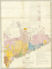
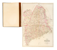
Rare full original publisher's color example of Matthew Carey's map of Maine, one of the best large format maps of Maine to appear prior to it becoming a state.
Six counties are shown, with all but Lincoln County stretching to the Canadian border. The northern regions are barely known, with no settlements and virtually no topographic information provided on the map. In the south, the extensive lake and river systems are noted, along with towns, roads, bays, islands, shoals, and other important features.
Maine would be admitted to the union in 1820, but up until this point it was still part of the Commonwealth of Massachusetts. The "District" had been created to manage the northmost counties of the Commonwealth. Attempts at statehood had started as early as 1785, but they would only grow to fruition during the War of 1812 when a weak response by Massachusetts to British occupation infuriated the residents of the district. As can be noticed in the east of the state, the borders would change following the creation of this map. The modern borders of the state would not be finalized until 1842.
Carey's General Atlas, first published in 1814, was the first American Atlas to be offered for sale with outline hand coloring on the maps.
Full original publisher's color is extremely rare.
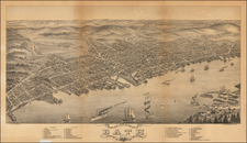
![[Portland & Cape Elizabeth to Moskito Island -- Centered on Kennebec River]](https://storage.googleapis.com/raremaps/img/small/50079.jpg)