|
||

|

|
|

|
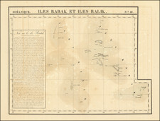
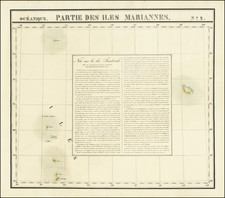
Important Early Sea Chart Covering The East Coast of Australia, New Zealand and the Western Pacific North to Northern Marianas
Rare First State!
This remarkable large format chart of the Southwestern Pacific was first issued one year after Aaron Arrowsmith's landmark 9 sheet Chart of the Pacific Ocean. Published on a significantly larger scale than Arrowsmith's chart, the chart offers a detailed and comprehensive look at the region through the lens of the voyage of Captain Thomas Butler of the Walpole and Captain Michael Hogan of the Marquis Cornwallis, whose tracks are meticulously charted across the southwestern Pacific, from New Zealand to the eastern coast of Australia and northward.
The era this chart represents was marked by a rapid escalation in global exploration and cartographic documentation. The United East India Company, in its quest to expand Britain's trading footprint in East Asia, and in particular Australia in this instance, dispatched numerous maritime expeditions. These voyages are traced in the lines and notations across the chart, revealing Britain's ambitious initiative to uncover the mysteries of the southwestern Pacific.
The geographical scope of the chart is expansive, featuring several key regions. It covers most of New Zealand, the eastern coast of Australia as known during the early 19th century, New Caledonia, the New Hebrides, the Solomon Islands, and an exploratory interpretation of the eastern half of New Guinea. In addition, the Northern Marianas and New Caroline Islands are depicted.
The chart's visual features also include engraved coastal profiles, aiding in the understanding of the terrain. The data collected through lunar observations and the chronometer corrections reveal the methodologies used in that era for maintaining the accuracy of the charted routes.
Walpole / Captain Thomas Butler
The voyage of the Walpole, undertaken by the East India Company (EIC) in 1794-1795, commanded by Captain Thomas Butler. the Walpole's journey was part of the East India Company's (EIC) strategic effort to establish and maintain lucrative trade routes between Britain and its Asian possessions, primarily focusing on China.
The Walpole set sail from Plymouth on June 23, 1794, armed with a letter of marque acquired on April 28, 1794, which authorized it to engage in privateering activities against enemies of the British Crown. Initially part of a fleet of Indiamen heading towards China, Captain Butler made a daring decision near St. Paul to deviate from the conventional route. His aim was to explore potentially quicker passages, reflecting the EIC's constant pursuit of more efficient trade routes to enhance profitability.
Navigating through the treacherous waters of Bass Strait, the Walpole proceeded northward without stopping at Port Jackson (modern-day Sydney). One of the notable achievements of the Walpole's voyage was the discovery of an island that Captain Butler named Walpole Island.
Marquis Cornwallis / Captain Michael Hogan
Michael Hogan, a merchant and shipowner, departed Cork, Ireland, in May 1795, as master of the convict ship Marquis Cornwallis bound for Australia, carrying 163 male and 70 female convicts. She also carried 36 soldiers of the New South Wales Corps, along with their families. During the voyage, a mutiny plot by Irish convicts was thwarted by Hogan's decisive action, which included firing upon the rebels and restraining their leaders. Upon arrival at Port Jackson on February 11, 1796, Hogan requested an inquiry, which exonerated him completely. Governor John Hunter acknowledged Hogan's respectable background and granted him six acres of town land, encouraging him to establish a much-needed private store.
In May 1796, Hogan departed Sydney for Bengal, India, armed with four guns salvaged from the wrecked HMS Sirius at Norfolk Island. His departure marked the end of his significant involvement in Australia, where he had briefly established himself amidst the challenges and opportunities of the early colonial era. The log book of the Marquis Cornwallis from February 1 to November 1 1796 is held by the State Library of New South Wales.
Rarity
Very rare.
OCLC locates only examples in the National Library of Australia. It is difficult to decipher how many examples are held there, but it appears not more than three. We note that the State Library of New South Wales holds a copy of the 1800 edition of the map.
There was an edition published in 1799 (not in Tooley), 1800 (Tooley 275), and in 1822 (by Richard Holmes Laurie, Tooley 276).
Robert Laurie (ca. 1755-1836) and James Whittle (1757-1818) formed their Fleet Street, London-based firm upon the 1794 death of their employer Robert Sayer, himself one of the dominant print and mapmakers of the last half of the 18th century.
Laurie & Whittle started managing Sayer's business as early as 1787. They took over all managerial duties when Sayer's health flagged in 1792, and they changed the imprint in 1794 upon his death. Sayer left the two a 21-year lease on the shop (at £100 a year) and on Sayer's Bolt Court premises, as well as an option to acquire stock and equipment at a preferential price of £5,000 payable over three years.
Robert Laurie retired from the firm in 1812, and his role was assumed by his son, Richard Holmes Laurie (1777-1858). The younger Laurie worked with James Whittle until the latter died in 1818. After R. H. Laurie died in 1858, Alexander George Findlay, FRGS (1812-1875) purchased the firm from his daughters. The firm continues today under another name, specializing in yachting charts.
Laurie & Whittle were prolific print and map publishers, and throughout their careers, they produced numerous very important and rare works. They carried on Robert Sayer's atlas business and were responsible for editions of The Complete East-India Pilot and The American Atlas.