|
||

|

|
|

|
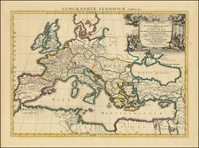
Wall Map of the Holy Roman Empire
Rare early state of Nicolas De Fer's monumental map of the Holy Roman Empire, published in France in 1705.
This 1705 wall map of the Holy Roman Empire, superimposed on the symbolic double-headed eagle, presents a comprehensive geographic and political representation of the empire. The map includes portraits of emperors from Charlemagne to the present and significant historical scenes and inset maps highlighting crucial locations within the empire. The present state seems to be an unusual and possibly unique survival, with the plans of Ratisbone and Vienna and the environs of Vienna at the bottom, a state we have not previously seen.
The central map is superimposed on the double-headed eagle, a potent symbol of the Holy Roman Empire representing its claim to be the legitimate successor to the ancient Roman Empire. The eagle's heads are at the top, with its wings extending to the left and right edges and its tail feathers at the bottom. On either side is an extensive history of the Holy Roman Empire and description of the region.
Surrounding the map are portraits of the Holy Roman Emperors, beginning with Charlemagne, who was crowned in 814, marking the formation of the Carolingian Empire. These portraits serve not only as a lineage but also as a visual affirmation of the empire's long-standing authority and continuity. The seven coats of arms on the tail feathers represent various significant entities and territories within the Holy Roman Empire, each symbolizing the diverse and feudal nature of the empire.
The two scenes depicted from July 1658 commemorate the election, consecration, and coronation of the emperor in Frankfurt. The three inset maps along the bottom provide detailed views of important locations within the Holy Roman Empire:
- Grande Salle de Ratisbonne (Regensburg): This inset illustrates the grand hall in Regensburg where the Imperial Diet met. It was a central institution in the governance of the empire, where matters of law, policy, and imperial decrees were deliberated.
- Environs of Vienna in 1705: This inset shows the areas surrounding Vienna, providing strategic and geographic insights into one of the empire's most significant cities. Vienna was not only the imperial residence but also a cultural and political hub.
- Plan of Vienna: The detailed plan of Vienna highlights the city's fortifications, key buildings, and urban layout, emphasizing its importance in the empire's defense and administration.
By 1705, the Holy Roman Empire was a vast and fragmented conglomeration of territories in Central Europe, stretching from the North Sea to the Mediterranean and from France to Poland. It comprised numerous semi-autonomous entities, including kingdoms, duchies, principalities, free imperial cities, and ecclesiastical territories. The emperor, elected by a select group of prince-electors, held nominal authority over this complex political landscape, but real power often lay with local rulers.
The empire's political structure was a unique blend of feudalism and elective monarchy, marked by a continual struggle for power between the emperor and the territorial princes. The War of Spanish Succession (1701-1714), during which this map was created, further complicated the political scene, as various European powers vied for dominance following the death of the childless Charles II of Spain.
Rarity and States of the Map
Issued for a number of years in the first half of the 18th Century (1705-1760), the map went through at least 3 states:
- State 1 (1705): Emperor Leopold I in the portrait.
- State 2 (1723): Emperor Joseph I replaces Leopold. Imprint of Danet. Sometimes with 3 text panels (left, bottom and right).
- State 3 (1745-1770 circa) 5 Monarchs at the top center.
The map is apparently rare on the market.
OCLC locates 1 example, in the National Library of Spain, with only the side text panels.
Nicholas de Fer (1646-1720) was the son of a map seller, Antoine de Fer, and grew to be one of the most well-known mapmakers in France in the seventeenth century. He was apprenticed at twelve years old to Louis Spirinx, an engraver. When his father died in 1673, Nicholas helped his mother run the business until 1687, when he became the sole proprietor.
His earliest known work is a map of the Canal of Languedoc in 1669, while some of his earliest engravings are in the revised edition of Methode pour Apprendre Facilement la Geographie (1685). In 1697, he published his first world atlas. Perhaps his most famous map is his wall map of America, published in 1698, with its celebrated beaver scene (engraved by Hendrick van Loon, designed by Nicolas Guerard). After his death in 1720, the business passed to his sons-in-law, Guillaume Danet and Jacques-Francois Benard.
![[ Enkhuizen ] Nieuwe Afteekening Van Alle De Banken, Canaalen, Tonnen en Dieptens. Geleegen voor de Stad Enkhuysen inde Zuyder Zee . . . .](https://storage.googleapis.com/raremaps/img/small/104258.jpg)
![[ Salzburg Lungau - Tamsweg District -- Road and Trekking Map for Southern Salzburg ]](https://storage.googleapis.com/raremaps/img/small/100458.jpg)