|
||

|

|
|

|
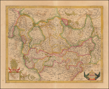
Fine example of Santini's Gallia Antiqua, based upon the work of eminent cartographer Jean Baptiste Bourguignon d'Anville in 1760.
The map iis a remarkable delineation of ancient Gaul as understood in the Roman era. It stands as a scholarly endeavor to depict the territories, tribal divisions, and Roman provinces based on archaeological findings and historical records of the time.
This exquisite map, including modern France, Belgium, Luxembourg and parts of Germany and Switzerland, serves as a window into the ancient world, meticulously etched to represent the geographical knowledge of Roman Gaul, with its intricate network of settlements, pathways, and the division of provinces such as Aquitania, Belgica, Germania, and Maxima Sequanorum. The cartography, emblematic of d'Anville's precision, delineates not only the natural topography but also the civil boundaries, transportation routes, and urban centers that constituted the fabric of Gallic society under Roman rule.
D'Anville's work is not only significant for its cartographic merit but also for its academic value. The cartographer's dedication to the accuracy of ancient geography and his critical approach to source material earned him a distinguished reputation among scholars.
Adorned with an elaborate cartouche that bespeaks the grandeur of the period, the map is as much a piece of art as it is a document of historical significance. The precision of d'Anville's work provides a lasting legacy of the ancient landscape, offering insights into Roman imperial administration and the enduring impact of Rome on the French territory.
Paolo Santini (1729-1793) was an Venetian engraver known especially for his religious prints and fine cartographic engravings. He published in Venice and may have a been a member of the clergy. In his maps, he largely adopted and adapted the work of his French counterparts, especially the brothers de Vaugondy.
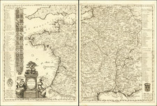
![(France under Clovis) Franciae Status sub Regibus Primae Stirpis, ex Observationibus D. Mart. Bouquet Benedictini atque ex Dissertationibus D. Lebeuf Canonici Autis . . . [The State of France under its First Kings. . .]](https://storage.googleapis.com/raremaps/img/small/89714.jpg)
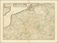
![[ Belgium ]. Les Provinces des Pays-Bas Catholiques ou a Most Exact Map of Flanders or ye Austrian Netherlands &c. . . .](https://storage.googleapis.com/raremaps/img/small/102631.jpg)