|
||

|

|
|

|
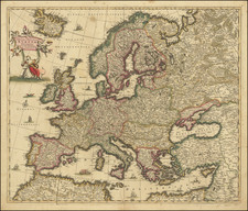
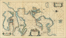
Detailed map of the western part of Roman Empire published by Santini in Venice and engraved by Remondini.
The 1779 map Tabula Geographica Romani Imperii provides an intricate depiction of the western portion of the Roman Empire, capturing its vast expanse across the British Isles, France, the Iberian Peninsula, and North Africa. The map offers a vivid portrayal of the ancient landscape, marking significant Roman settlements, roads, and geographical features, and is a testament to the Empire's monumental historical influence.
The Roman Empire, at its zenith, was a sprawling political and social structure that governed a diverse array of cultures and regions. By capturing the territories from the misty isles of Britannia to the sun-drenched deserts of North Africa, this map encapsulates the breadth of Roman authority and civilization. The western domain, illustrated in this map, highlights the administrative and military ingenuity of Rome, underscoring its ability to control vast and varied territories through a network of roads, cities, and military outposts.
Description of Regions:
-
British Isles (Britanniae): The Roman conquest of Britannia began in AD 43 under Emperor Claudius. The map details Roman Britain's major towns and roads, such as Londinium (London), Eboracum (York), and the defensive boundary of Hadrian's Wall (marked as the Pictish frontier). The depiction of these locations illustrates the strategic importance of the isles in providing resources and military advantages.
-
Gallia (France): Roman Gaul, divided into several provinces including Gallia Narbonensis, Aquitania, and Belgica, reflects the administrative complexity and cultural diversity of the region. Cities like Lugdunum (Lyon) and Lutetia (Paris) highlight the Roman influence on urban development and cultural life in Gaul.
-
Iberia (Spain and Portugal): The Iberian Peninsula, comprising provinces such as Hispania Tarraconensis, Lusitania, and Baetica, shows the deep imprint of Roman governance. The map features ancient cities like Tarraco (Tarragona), Emerita Augusta (Mérida), and Hispalis (Seville), which were vital economic and cultural centers.
-
North Africa: This region includes the prosperous provinces of Africa Proconsularis and Numidia, extending into Mauretania. Cities like Carthage and Leptis Magna symbolize the Roman Empire's wealth and architectural grandeur. The depiction of the African provinces underscores the critical role of this region in supplying grain and other goods to Rome.
Paolo Santini (1729-1793) was an Venetian engraver known especially for his religious prints and fine cartographic engravings. He published in Venice and may have a been a member of the clergy. In his maps, he largely adopted and adapted the work of his French counterparts, especially the brothers de Vaugondy.
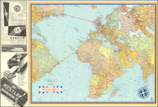
![[Eurpean and American Air Routes] TWA Trans World Airline U.S.A. • Europe • Africa • Asia Air Routes](https://storage.googleapis.com/raremaps/img/small/89027.jpg)