|
||

|

|
|

|
Large map of the Ancient World, as known to the ancient civilizations of Europe, based upon an earlier map published by J.B.B. D'Anville in Paris.
The map shows a modern outline of the regions of Europe known at the time of Ptolemy, using ancient place names and omitting regions which had not yet been "discovered" by Europeans.
The text describes a discrepancy between the geographical knowledge of the ancient world and that of the more recent past or present, as portrayed this map. The first part emphasizes that contemporary maps have expanded beyond the geographical understanding of the ancient world, particularly in Asia and surrounding islands.
The second part reflects on the hypothetical scenario where the contemporary breadth of geographical knowledge (encompassing all three parts of the world: Europe, Asia, and Africa) is applied to the format of ancient maps. The result would be an ancient map that appears "too sparse and lacking in its own resources" because the old geographical scope is much narrower compared to today's understanding. This signifies that if ancient geographical concepts were to be applied to modern maps, they would appear insufficient and limited due to the significant expansion of geographical knowledge over time.
Paolo Santini (1729-1793) was an Venetian engraver known especially for his religious prints and fine cartographic engravings. He published in Venice and may have a been a member of the clergy. In his maps, he largely adopted and adapted the work of his French counterparts, especially the brothers de Vaugondy.
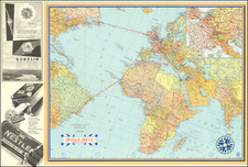
![(Apollo 14 - Recovery Tracking Manuscript) [Post lunar landing recovery map and related ephemera from aboard USS New Orleans including NASA issued Apollo 14 insignia patch] Apollo Mission Plotting Chart (AMP) 4th Apollo Edition, January 1969.](https://storage.googleapis.com/raremaps/img/small/76611.jpg)