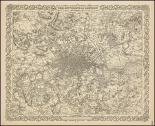
![[ London ] An Exact Survey of the City's of London Westminster ye Borough of Southwark and the Country Near Ten Miles Round Begun In 1741 & Ended in 1745 By John Rocque Land Surveyor & Engrau'd By Richard Parr / A New and Accurate Survey Of the Cities of London and Westminster The Borough of Southwark with The Country about it for nineteen Miles in Length and thirteen in Depth . . . By John Rocque](https://storage.googleapis.com/raremaps/img/small/96431.jpg)


|
||

|

|
|

|
One of the finest maps of - what is now - Greater London ever produced. It would appear that John Rocque, a French Huguenot, emigrated with the rest of his family to London in the 1730s, where he began to ply his trade as a surveyor of gentleman's estates, and with plans of Kensington Gardens, and Hampton Court. However, in 1737 he applied his surveying skills to a much great task, that of surveying the entire built-up area of London. Began in the March of 1737, the map would take nine years to produce, eventually being engraved upon 24 sheets of copper and published in 1746. Whilst engaged upon this project Rocque was also working on the present map of the country ten miles round London, and on a scale of 51/2 inches to the mile, or one quarter of the scale of the large survey. The completed map was published in 1746.
*First issued 1746 this example c.1751-54 with all the points listed in Howgego i.e. Sheet 1 has imprint ‘Published by I. Rocque...Feby, 13th 1744 Next ye Duke of Grafton’s Head Hide Park Corner; 2) sheet 6 has, ‘Published 29th of April...by John Rocque 1746; and 3) sheet 13 has, ‘Publish’d ye 28th of Decr 1744...by I. Rocque in Hide Park Road’ but with the additional place-names etc. to that date. In addition for state 5 (i) the names 'the Kings Old Road' and 'the Kings New Road' have been added to existing roads in Hyde Park, both labels immediately under the Serpentine; (ii) 'HANNUEL' is now corrected to 'HANWELL' [Sheet XIV: the left-hand strip, second sheet down]; (iii) On Barnes Common, 'Peace Bridge' has been revised to 'Priests Bridge' [Sheet X], below the start of the label 'BARNES COMMON.
Plus **sheet 16 (here sometime supplied from another copy) has the additional scales: two in the first state, 4 in the slightly later issues.
Old shelf number labels to feet of spines, the verso of each sheet numbered in an old hand. Handsomely presented.
John Rocque (circa 1704-1762), an 18th-century surveyor of Huguenot descent, left a profound imprint on the topographical representation of England, particularly through his elaborate maps of London and its surroundings. Despite his significant contributions, his life, both personally and professionally, remains somewhat cloaked in mystery.
Born likely around 1704 or 1705 to French Huguenot parents who migrated to Geneva following the revocation of the Edict of Nantes, Rocque found his calling in England. There, he and his siblings were known to have spent significant parts of their lives. His journey into surveying took off in 1734, with his first recognized work involving a survey of Richmond House and its gardens. This engagement emerged at a fortuitous time when the landscaping and design of the nobility's estates were witnessing renewed interest, which required accurate surveying—a skill Rocque exemplified.
Rocque didn't confine his talents to surveying alone but ventured into printselling, owning a shop near Hyde Park Corner by 1743. This enterprise reflected his energetic nature and the breadth of his ambition, contributing to his reputation for high-quality work, evidenced by the size of his workforce, which included up to ten draughtsmen and engravers at times.
In his later years, Rocque faced adversity, with his shop and entire stock in Whitehall being devastated by fire in 1750. However, his resilience saw him bounce back, and despite several relocations, Rocque maintained his business operations around the Strand area. By the 1750s, his work had taken him to Dublin, where he made substantial contributions in the form of numerous Irish maps and various English county maps.
On the personal front, Rocque married twice but had no known children from either marriage. His first wife was Marthe, whom he married by 1728, and following her death, he married Mary Anne Bew in 1751. Rocque's health began deteriorating towards the end of his life, leading to his death on January 27, 1762. His widow, Mary Anne, continued to manage the business for several years after his demise.
![(London) Ch. de Withal [Whitehall Palace]](https://storage.googleapis.com/raremaps/img/small/98051.jpg)