|
||

|

|
|

|
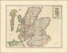
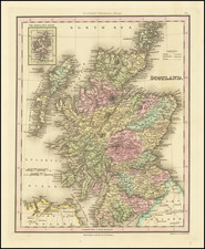
Nicolas de Fer's 1705 Map of Scotland: "Table des Latitudes et Longitudes des Principaux Lieux du Royaume d'Escosse"
Nicolas de Fer's 1705 map, Table des Latitudes et Longitudes des Principaux Lieux du Royaume d'Escosse, provides a meticulous depiction of Scotland's geographical features and significant locations. De Fer, a prominent French cartographer of the late 17th and early 18th centuries, was renowned for his detailed and artistically crafted maps, which were esteemed for their accuracy and aesthetic appeal.
The map is distinguished by its comprehensive detailing of latitude and longitude, which reflects the period's advancements in navigational and mapping techniques. Notably, it includes the Shetland and Faroe Islands, emphasizing the strategic and navigational importance of these northern territories. De Fer’s meticulous inclusion of various geographical features, such as the Isles of the Hebrides and the Orkneys, underscores the map’s utility for maritime navigation and its relevance to contemporary geopolitical interests.
Each province of Scotland is meticulously outlined and color-coded, with key locations such as Edinburgh, Inverness, and Aberdeen clearly marked. The map's inset panels provide a detailed view of the Shetland and Faroe Islands, illustrating their significant geographical features and relative positions. The extensive table of latitudes and longitudes on the map’s right margin serves as an invaluable reference for scholars and navigators alike, showcasing de Fer’s commitment to precision.
This map emerges from an era marked by significant cartographic advancements and a growing European interest in accurate geographical documentation. By the early 18th century, Scotland was experiencing political turbulence and eventual union with England in 1707, a union that fundamentally altered its governance and political landscape. De Fer’s map predates this union, capturing Scotland in a period of relative political autonomy and complexity.
Nicholas de Fer (1646-1720) was the son of a map seller, Antoine de Fer, and grew to be one of the most well-known mapmakers in France in the seventeenth century. He was apprenticed at twelve years old to Louis Spirinx, an engraver. When his father died in 1673, Nicholas helped his mother run the business until 1687, when he became the sole proprietor.
His earliest known work is a map of the Canal of Languedoc in 1669, while some of his earliest engravings are in the revised edition of Methode pour Apprendre Facilement la Geographie (1685). In 1697, he published his first world atlas. Perhaps his most famous map is his wall map of America, published in 1698, with its celebrated beaver scene (engraved by Hendrick van Loon, designed by Nicolas Guerard). After his death in 1720, the business passed to his sons-in-law, Guillaume Danet and Jacques-Francois Benard.