|
||

|

|
|

|
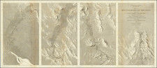
Traversing Highway 395 - The Three Flags Highway
Rare promotional brochure and map, issued by the Three Flags Highway Association, based in Lakeview, Oregon, to promote US Highway 395, known as the Three Flags Highway.
The materials include a map and a pamphlet, both of which are aimed at highlighting the scenic and strategic importance of the route that links Canada, the United States, and Mexico. The route, designated in the early 1930s, traverses some of North America's most picturesque landscapes, from the vast expanse of British Columbia to the sun-drenched deserts of Southern California.
In 1931, in an effort to stimulate travel and commerce, the Three Flags Highway Association was formed to advocate for a north-to-south highway extending across the North American continent. By 1935, this vision was realized with the formal assignment of the federal highway number US Highway 395. The route’s designation as the Three Flags Highway underscores its international significance, connecting diverse ecosystems and communities across three countries. By the following summer, it reached as far south as San Diego, aligning with the 1935 California Pacific International Exposition, thereby cementing its status as a vital artery of cultural and economic exchange.
The map shows Highway 395 from the Canadian border down to Los Angeles and San Diego. The red line snaking down the map not only guides the traveler but also symbolizes the connectivity and unity between distant locales. The pamphlet, adorned with vibrant illustrations and inviting text, serves as a testament to the era's marketing strategies, enticing motorists to embark on a scenic journey through the continent's heart.

![[ Chinese Voyages To America, etc. ] Memoires De Litterature, Tires Des Registres De L'Academie Royale Des Inscriptions et Belles-Lettres Depuis l' annee M. DCC. XVIII. julques & compris l'annee M. DCC. XXV Tome Quarante-Neuvieme](https://storage.googleapis.com/raremaps/img/small/101296.jpg)