


|
||

|

|
|

|
Dutch Edition of a Cartographic Landmark
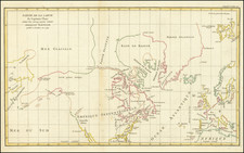
Extremely rare "Amsterdam" of Louis Hennepin's important map of North America, published for Jan ten Hoorn's Beschryving van Louisania, Nieuwelijks ontdekt ten Zuid-Westen van Nieuw-Vrankryk, door order van den Koning, the first Dutch language edition of Hennepin's monumental Description de la Louisiane, first published in 1683.
Hennepin's map is perhaps best known as the first map to incorporate the reports of Robert La Salle's journey from the Niagara Falls region, through the Illinois Company and the Upper Mississippi River and the first appearance of the name Louisiana. The map locates Fort Creve Coeur, Michilimackinac, etc. Lakes Superior, Huron and Erie appear with their modern names, while the Atlantic Ocean appears as the Zee Van Canada (Canadian Sea).
Hennepin's map is drawn directly on the explorations of the French fur trader Jolliet and the Jesuit Marquette. In May 1673, the two led an expedition from Green Bay westward via the Fox and Wisconsin Rivers to find the upper Mississippi. Once they reached it, they travelled south past the Missouri, Ohio and Arkansas Rivers before turning back near present-day Natchez. On their return, they used the Chicago and Des Plaines Rivers to emerge on Lake Michigan at present-day Chicago. The information gathered by the explorers is the basis for the present map rendered by Hennepin.
Robert La Salle (1643-1687) received a grant of land on the island of Montreal in 1666. In 1668, he met with 2 Iroquois Indians, who communicated to him the existence of a westward flowing river, which corresponds with the description of the Ohio River. La Salle joined a Sulpician mission to the west, leaving Montreal on July 6, 1669.
The expedition went via the St. Lawrence to Lake Ontario, then on to the Niagara River. They met Louis Jolliet at an Indian Village on the western shores of Lake Ontario, at which point he separated from the party, desiring to search for the river he had heard about from the Iroquois. Over the next several years, La Salle apparently travelled the area, although his report of having descended the Ohio River to the falls at Louisville is viewed with skepticism.
In 1672, La Salle met the newly appointed Governor of Canada (Comte de Frontenac), who sent La Salle back to France to negotiate a monopoly of the fur trade. La Salle returned on the same ship as Father Louis Hennepin, a Recollect Friar who was headed for New France. La Salle hired Hennepin to serve as the Chaplain at Fort Frontenac, the base of operations from which La Salle and Frontenac hoped to open up the west. After building a ship near Niagara Falls, La Salle and Hennepin, along with Henri de Tonty, set sail, crossing Lake Erie to Lake Huron. During the voyage, Hennepin named Lake St. Clair. By August 1679, they reached Michilimackinac and later Green Bay (Baye des Puans), which is named on the map.
La Salle and a small party explored Lake Michigan, meeting up back up with Tonty at the mouth of the Miami (St. Joseph) River, where they constructed Fort Miami. On December 3, 1679, the combined party ascended the river to the South Bend, Indiana area, and crossed the Kankakee River, before descending to central Illinois, constructing Fort de Crevecoeur on Lake Peoria. La Salle then sent out a party led by Michel Aco, which included Hennepin, to explore the Upper Mississippi River.
The party descended the Illinois River (Seignelay R. on the map), then up the Mississippi River to beyond the confluence of the Wisconsin River, to Lake Pepin (the Lake of Tears), where they were captured by Indians on April 11, 1680. They were transported past the Falls of St. Anthony to the Lake Baude area, before being rescued by Daniel Greysolon Duluth (Tonty's cousin), who was then exploring the region. With Duluth, the party continued to Lake Mille Lac in northern Minnesota, where Duluth entered into a treaty with the Sioux Indians. Hennepin then returned to New France via the Falls of St. Anthony and returned to France, where he published his first book in January 1683.
Hennepin's map illustrates the territory through which La Salle had travelled and also the course of the Mississippi River as far south as the Arkansas River, which had been reached by Marquette and Jolliet. As Wheat points out, La Salle and later French cartographers recorded the course of the river as progressing further west, making Hennepin's map remarkably accurate in this regard for its time.
Rarity
The Dutch edition of Hennepin's map is very rare on the market, as is Jan ten Hoorn's Beschryving van Louisania.
This is the first example of the map we have ever seen separately on the market.

![Carte Du Canada ou de la Nouvelle France et des Decouvertes qui y ont ete faites . . . [Map of Canada or New France and the Discoveries Made Therein . . .]](https://storage.googleapis.com/raremaps/img/small/94450.jpg)
![[ The Old Northwest Territory ] Il Paese De Selvaggi Outagamiani, Mascoutensi Illinesi E parte Delle VI Naxioni](https://storage.googleapis.com/raremaps/img/small/75927.jpg)