


|
||

|

|
|

|
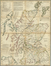
Fine large map of Scotland, with an impressive decorative cartouche.
At the bottom left is a detailed index of cities.
This fine large map presents Scotland with exceptional clarity and attention to detail. The map marks the locations of forts, pathways, strategic military avenues, and historical battlefields. The topography shows mountain ranges and numerous water features, including lochs.
In the top-right corner, there is a detailed inset showcasing the Shetland Islands. The map's northwestern quadrant features an ornate title cartouche amidst a scenic backdrop, which incorporates the Scottish national emblem and several pieces of artillery.
Sayer & Bennett refers to the partnership of Robert Sayer (ca. 1724-1794) and John Bennett (fl. 1760-d.1787), which lasted between 1774 and 1783. Bennett had been Sayer’s apprentice. The pair specialized in American atlases, based on the work of Thomas Jefferys, who plates had been acquired by Sayer when Jefferys went bankrupt in 1766. They also began publishing navigational charts in the 1780s and quickly became the largest supplier of British charts in the trade. However, in 1783 Bennett lost control of his mental faculties and the partnership dissolved as a result. Sayer’s business was later passed to his employees, Robert Laurie and James Whittle.
![[ Scotland ] A New Map of Scotland or North Britain Drawn from the most approved Surveys and Regulated by Astronomical Observations, By Lieutenant Campbell . . . 1794](https://storage.googleapis.com/raremaps/img/small/102873.jpg)
![A New Map of the North Part of Scotland [North sheet only]](https://storage.googleapis.com/raremaps/img/small/89745.jpg)