


|
||

|

|
|

|
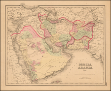
The First Woodcut Map of Persia.
Fine woodcut map of Persia, the first such map ever produced, presented here in the second edition, printed by Johann Reger in Ulm in 1486.
The first and second printings can be differentiated by the inclusion or not of title text at the top of the map and by the text setting on the back of the map.
Classical Regions Named and Depicted
To the modern viewer, this map covers areas most readily associated with modern-day Iran and its neighbors. In Ptolemy's time, the area home to several regions, namely Susiana, Assiria, Media, Persidis, Parthia, Hircania, Carmania Deserta, and parts of Carmania. These represent a collection of ancient regions and civilizations that played pivotal roles in the history and development of the Near East and wider ancient world. Susiana, corresponding to parts of modern-day Iran and Iraq, was known for its capital, Susa (shown in the north of the region), a major city in the ancient world. Assiria, or Assyria, was a powerful empire known for its military prowess and advancements in governance, influencing regions far beyond its borders. Media, located in what is now northwestern Iran, was notable for its role in the fall of Assyria and the establishment of the Median Empire. Persidis, or Persia, evolved into the Achaemenid Empire, which at its height was one of the largest empires in history, known for its administration system and road networks. Parthia, in northeastern Iran, was renowned for its horse archers and successfully challenged the Roman Empire for dominance in the East. Hircania, along the southern shores of the Caspian Sea, was known for its dense forests and as a frontier of various empires. Carmania Deserta and the inhabited parts of Carmania (modern-day Kerman) were important for their strategic location in Iran, serving as a crossroads between the East and West. Collectively, these regions contributed significantly to cultural exchanges, military campaigns, and the spread of ideas, shaping the historical trajectory of the ancient Near East and the broader world.
Claudius Ptolemy (fl. AD 127-145) was an ancient geographer, astronomer, and mathematician. He is known today through translations and transcriptions of his work, but little is known about his life besides his residence in Alexandria.
Several of his works are still known today, although they have passed through several alterations and languages over the centuries. The Almagest, in thirteen books, discusses astronomy. It is in the Almagest that Ptolemy postulates his geocentric universe. His geometric ideas are contained in the Analemma, and his optical ideas were presented in five books known as the Optica.
His geographic and cartographic work was immensely influential. In the Planisphaerium, Ptolemy discusses the stereographic projection. Perhaps his best-known work is his Geographia, in eight books. However, Ptolemy’s ideas had been absent from western European intellectual history for roughly a thousand years, although Arab scholars interacted with his ideas from the ninth century onward.
In 1295, a Greek monk found a copy of Geographia in Constantinople; the emperor ordered a copy made and the Greek text began to circulate in eastern Europe. In 1393, a Byzantine diplomat brought a copy of the Geographia to Italy, where it was translated into Latin in 1406 and called the Cosmographia. The manuscript maps were first recorded in 1415. These manuscripts, of which there are over eighty extant today, are the descendants of Ptolemy’s work and a now-lost atlas consisting of a world map and 26 regional maps.
When Ptolemy’s work was re-introduced to Western scholarship, it proved radically influential for the understanding and appearance of maps. Ptolemy employs the concept of a graticule, uses latitude and longitude, and orients his maps to the north—concepts we take for granted today. The Geographia’s text is concerned with three main issues with regard to geography: the size and shape of the earth; map projection, i.e. how to represent the world’s curve proportionally on a plane surface; and the corruption of spatial data as it transfers from source to source. The text also contains instructions as to how to map the world on a globe or a plane surface, complete with the only set of geographic coordinates (8000 toponyms, 6400 with coordinates) to survive from the classical world.
![[Empire of Alexander The Great] Antiquor? Imperiorum Tabula in qua prae caeteris, Macendonia seu Alexandri Magni et Expeditiones exarantur . . .](https://storage.googleapis.com/raremaps/img/small/70608.jpg)
![[Iran, Afghanistan, Turkmenistan, Uzbekistan and Kazakhstan] Tabula Asiae VII](https://storage.googleapis.com/raremaps/img/small/84898.jpg)