


|
||

|

|
|

|
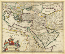
Delineating the geopolitical dynamics of the late 18th century, Etats Due Grand-Seigneur En Asie, Empire De Perse, Pays Des Usbecs, Arabie et Egypte is a map published in 1778 by the renowned mapmakers, Paolo Santini and Giovanni Antonio Remondini, in the heart of Venice. This map provides an intricate portrayal of the expanses of the Turkish Empire, highlighting the territories reaching out to the Black Sea, Georgia, the Caspian, Uzbekistan, the Indian Ocean, Saudi Arabia, Egypt, and the Red Sea.
Santini and Remondini's map serves as a visual testament to the height of the Ottoman Empire's reach and influence, encompassing lands as far as modern-day Iran (known then as Persia), the territories of the Uzbeks, and the extensive landscapes of Arabia and Egypt. This time was characterized by complex power relations, shifting alliances, and trade routes that extended from Europe to Asia. The map, therefore, stands as a rich historical document, shedding light on the geopolitical context of the period.
Each geographical feature, from major cities and rivers to mountain ranges, is rendered with remarkable precision, a testament to the mapmakers' comprehensive understanding of these territories. This, coupled with the beautifully detailed title cartouche, imbues the map with both aesthetic charm and historical significance.
The distinct style and detailed annotations reflect the Enlightenment-era traditions of cartography, characterized by the integration of scientific rigor and artistic elegance. As such, Etats Due Grand-Seigneur En Asie, Empire De Perse, Pays Des Usbecs, Arabie et Egypte provides an insightful lens through which to explore the intricate web of geopolitical landscapes of the 18th century, offering a profound understanding of a pivotal epoch in world history.
Paolo Santini (1729-1793) was an Venetian engraver known especially for his religious prints and fine cartographic engravings. He published in Venice and may have a been a member of the clergy. In his maps, he largely adopted and adapted the work of his French counterparts, especially the brothers de Vaugondy.

![[ Black Sea / Istanbul ] Nova Mappa Maris Nigri Et Freti Constantinopolitani . . .](https://storage.googleapis.com/raremaps/img/small/104276.jpg)
![[ Aegean Sea ]](https://storage.googleapis.com/raremaps/img/small/96557.jpg)