|
||

|

|
|

|
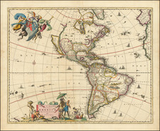
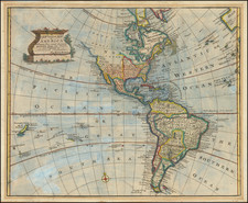
This rare "8-sheet" map of America is something of a mystery, employing and irregular configuration to depict what amounts to a 4.5 foot tall by 3.5 foot wide irregular expanse.
Published by Lowry with maps dated between 1828 and 1831, the map captures in impressive detail the "latest discoveries" in America, most notably those in the Arctic Regions.
The arctic regions reflect the discoveries of the Mackenzie River Expedition (1825-27), the discoveries of William Edward Parry aboard the HMS Fury and HMS Hecla (1821-22) and information from the Hudson's Bay Company.
In the western United States, a number of rivers are shown flowing from a unknown sources far from the Pacific Ocean to San Francisco Bay, "San Luis," "S. Luis Obispo" and "S. Luis Rey" and the San Diego each traversing what would actually be impassible mountain ranges which had yet to be discovered. The details of the Rio Colorado are quite interesting, extending north to a mountain range which allows it to nearly intersect with the northern reaches of the Rio Grande River.
The Upper Missouri River and its tributaries are well displayed. On the opposite side of the Rocky Mountains, the Clark River and Columbia River both reach far into the region which would become British Columbia, with the border west of the Rocky Mountains between the US and British America intentionally left out following the 1818 Treaty which made Oregon Country a neutral region.
Rarity
AMPR lists one copy, offered in 1983. RBH lists a single example at auction (this copy).
We note 1 example at the University of Alaska, Fairbanks. OCLC locates a copy of the map bound into a volume of the Encyclopaedia metropolitana (1830) in the Bayerische Staatsbibliothek.
Not listed in Wheat.
![[Globe with California as an Island on Allegorical Jesuit Engraving] Saeculum Nostrum in Illuminatione Vultus Tui Psal 89](https://storage.googleapis.com/raremaps/img/small/93732.jpg)