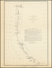
![[San Diego County Before Orange, Riverside and Imperial Counties] Sketch Map of San Diego County Showing the Position of Mines and Minerals Referred to in the 6th Annual Report of the State Mineralogist of California . . . .1886 By Henry G. Hanks](https://storage.googleapis.com/raremaps/img/small/104557.jpg)


|
||

|

|
|

|
Maximum San Diego County - Anticipating the Salton Sea!
Fine map of San Bernardino County, prior to the creation of Orange County, Riverside County and Imperial County.
Published to accompany the Sixth report of the State Mineralogist, Henry G. Hanks, the map is colored based upon geological features and presents a well defined topographical and hydrographical overview of the county.
One of the more remarkable features is the well defined Dry Lake east of Borrego Springs, which notes that it reaches a depth of 250 feet below sea level, which would rival Death Valley, California (lowest point being 282 feet below sea level) for the the lowest point in North America. It shows the area 19 years prior to the flooding which in 1905 would create the Salton Sea, the largest lake by surface area in California.
The map is primarily focused on locating mountains, rivers, springs, etc, but also shows the primary railroad routes throughout the County.
Rarity
The map is very rare on the market, as is the report (6th Report of the State Mineralogist).
![[ Earthquake Fault Lines ] Reconnaissance Map of the West Side of Sacramento Valley . . . 1920](https://storage.googleapis.com/raremaps/img/small/101680.jpg)
![Nouvelle Carte Du Mexique, Du Texas Et D'Une Partie Des Etats Limitrophes . . . 1840 [Proposed Railroads In Texas -- First Appearance of Arizona on a Printed Map]](https://storage.googleapis.com/raremaps/img/small/103480.jpg)