
The item illustrated and described below is sold, but we
have another example in stock. To view the example which
is currently being offered for sale, click the
"View Details" button below.


|
||

|

|
|

|
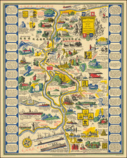
Stock# 101988
Description
Proof State -- Drawn By An Early Female Pictorial Map Illustrator
Fascinating annotated proof state of this famous pictorial map of the area between Lake Erie and Lake Ontario.
Provides numerous historical vignettes and facts about the region.
The annotations and corrections include:
- Proposed title with guidelines penciled in
- Penciled suggestions for text in blank side panel text boxes
- Guide notes for color shading.
- Charge of location for copyright info at bottom right.
The final lettering in the image (New York and Anda) on either side of the Hudson River has not yet been added.
Compiled by by Josephine Wilhelm Wickser and drawn by Midred C. Green, the final version of the map would appear in full color, with the copyright updated to 1931.
![[New England] Tierra Nueva](https://storage.googleapis.com/raremaps/img/small/64626.jpg)
![[Pictorial Map of the United Arab Republic] Kharitat Musawwarat al-Jumhuriya al-'Arabiya al-Muttahida / خريطة مصورة الجمهورية العربية المتحدة](https://storage.googleapis.com/raremaps/img/small/55146.jpg)
![[ Downtown St. Helena ] Mattioli's in your Pocket Guide St. Helena -- 13th Annual Edition [ Napa Valley, CA ]](https://storage.googleapis.com/raremaps/img/small/102768.jpg)