|
||

|

|
|

|
The C.A. Roberts Copy
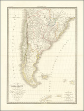
Fine large railroad map of Argentina, published at time when the country was rapidly growing with European immigrants and European businesses were looking for commercial opportunities for investment.
The map includes the name C.A. Roberts embossed into the front cover in gilt. Given the custom presentation and time period, this map is likely the C.A. Roberts who was employed as a senior manager by the Great Western Railway in the first part of the 20th Century.
The present map, published in London, meticulously details Argentina's railroad infrastructure, with large inset maps covering the area around Buenos Aires, the wider Rio de La Plata area and Bahia Blanca.
The map legend details the various railroad lines (trochas) and boundaries with specific color codes, with the size in parenthesis noting the gauge of the line). Here is the translated and color-coded list based on the typical visual cues:
TROCHA ANCHA (1m 676)
- Ferrocarril Sud de Bs Aires: Solid dark blue line
- Oeste de Bs Aires: Solid pink line
- De Bs Aires al Pacífico: Solid green line
- Central Argentino: Solid red line
- Rosario a Pto.Belgrano: Solid dark gray line
- Ferrocarriles del Gobierno: Black line with white dashes
TROCHA MEDIA (1m 435)
- Ferrocarril de Entre Ríos: Dotted dark blue line
- Nordeste Argentino: Dotted pink line
- Central de Bs Aires: Dotted green line
TROCHA ANGOSTA (1m 00)
- Ferrocarril Prov. de Santa Fé: Solid yellow line
- Central Córdoba: Solid orange line
- Trasandino: Solid brown line
- Midland de Bs Aires: Solid light blue line
- Prov de Bs Aires: Solid beige line
- Cía Gral de F.F.C.C.Prov. de Bs Aires: Black line with white and black dots
Other details:
- Otros Ferrocarriles: Solid gray line
- Límites Internacionales y...: Black line with double white dashes
- Límites Provinciales: Double solid black lines
- Límites de Partidos y Departamentos: Dashed black line
- Canales de Desagüie: Solid black line
- Caminos: Double dashed black lines
This legend provides a detailed view of the various types of railroads operating in Argentina at the time the map was created, denoted by different colors and patterns. The legend also includes symbols for administrative boundaries and infrastructure like roads and canals.