|
||

|

|
|

|
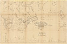
The First Transcontinental Highway in the United States.
This map, copyrighted in April 1915, was created by the National Highways Association and cartographer John C. Mulford under the direction of A. L. Westgard. It illustrates the proposed alignment of the Lincoln Highway, the first transcontinental road for automobiles in the United States. Spanning from New York to San Francisco, the highway traverses 13 states, touching six state capitals and 113 counties, directly serving a population of over 22 million. The red line on the map marks the tentative route of the highway, passing through 725 cities, towns, villages, and hamlets. The map provides a detailed look at the planned highway system across the United States, showing major cities and topographical features.
Additionally, the map includes the tentative designation of several other national highways, such as the Northern, Pacific, Central, Atlantic, Appalachian, Atlantic Southwest, Mississippi, Canada-Gulf, Great Lakes-Atlantic, Great Lakes-Gulf, Lakes-Mountain-Pacific, Lakes-Southwest, Meridian, Northwest, Puget-Gulf, Rocky Mountain, Santa Fe', South Central, Connecticut Valley, Indiana-Atlantic, Indiana-Pennsylvania, New York-Lake Erie, Massachusetts-Champlain, Missouri-Yellowstone, New York-St. Lawrence, New Hampshire, Ohio-Mackinac, Ohio-Tennessee, Ontario-Chesapeake, Pennsylvania-Lake Superior, Salt Lake-Montana, and Wisconsin-Dakotas.
The creation of the Lincoln Highway was a landmark in American transportation history, as it was the first transcontinental road for cars in the United States. Conceived in 1913 by the Lincoln Highway Association, the highway aimed to connect the Atlantic and Pacific coasts, running from Times Square in New York City to Lincoln Park in San Francisco. This ambitious project embodied the spirit of innovation and progress that characterized the early 20th century, providing critical infrastructure that facilitated the growth of automobile travel and commerce. By promoting the development of a unified national road network, the Lincoln Highway played a pivotal role in shaping the American landscape and economy, catalyzing the growth of rural and urban areas alike.
Moreover, the Lincoln Highway set a precedent for future highway construction and marked the beginning of America's enduring relationship with the automobile. Its development spurred the establishment of numerous roadside businesses, including gas stations, motels, and diners, which became integral to the American travel experience. The highway's impact extended beyond transportation, influencing American culture and society by promoting mobility, tourism, and the idea of freedom associated with road travel. As a pioneering venture, the Lincoln Highway paved the way for the creation of the Interstate Highway System in the 1950s, which further revolutionized transportation in the United States. The legacy of the Lincoln Highway endures today as a symbol of American ingenuity and the transformative power of infrastructure development.
![[ Atlas of The United States ] Karte von Amerika](https://storage.googleapis.com/raremaps/img/small/84353mp2.jpg)
![United States Atlas [rolled]](https://storage.googleapis.com/raremaps/img/small/91367.jpg)
![[ Military Departments ] Johnson's New Military Map of the United States Forts, Military Posts & all the Military Divisions with Enlarged Plans of the Southern Harbors . . .](https://storage.googleapis.com/raremaps/img/small/101114.jpg)