|
||

|

|
|

|
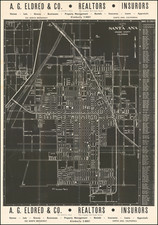
Fascinating White on Black Map of Santa Ana, California
This promotional map, released in the late 1940s, provides a detailed plan of the city of Santa Ana and Vicinity, California.
Promoting A.G. Eldred & Co., a firm specializing in real estate and insurance, the map is not merely a navigational aid but also a marketing tool, crafted to encapsulate the burgeoning post-war growth and architectural landscape of Santa Ana during the mid-20th century.
The map itself, detailed and utilitarian in nature, delineates the city's grid, streets, and notable landmarks with remarkable precision. Main thoroughfares, residential blocks, and significant industrial zones are marked clearly, providing a snapshot of Santa Ana's urban and suburban development. Such maps were indispensable for prospective homeowners, businesses, and investors navigating the rapidly expanding cityscape of post-war America.
The cover text includes an advertisement for A.G. Eldred & Co.'s services and a testament to the company's commitment to the Santa Ana community as well as Kellogg’s Auto & Trailer Courts.
White on black map images are quite unusual and, in this instances, visually appealing.