|
||

|

|
|

|
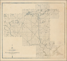
The map shows a portion of Minnesota, centered around Mille Lacs Lake.
The map highlights several counties including Crow Wing, Morrison, and Benton, with county lines clearly delineated. The map is dense with geographical names, indicating towns, lakes, rivers, and other topographical features. It has a grid overlay, suggesting survey sections, typical of land division for property ownership and sale.
The text on the map promotes settlement and development in the area, noting the counties' central location between St. Paul, Minneapolis, and Duluth, and emphasizing the health benefits of the climate, the availability of natural resources, and the presence of railway facilities. There are also references to available land for farming, stock raising, and dairying, indicating an agricultural focus.
![[Hastings, Minnesota]](https://storage.googleapis.com/raremaps/img/small/92128.jpg)


![[ Great Lakes - Upper Midwest -- Western Canada ] Partie Occidentale Du Canada, contenant les cinq Grands Lacs, avec Pays Circonvoisons](https://storage.googleapis.com/raremaps/img/small/98377.jpg)