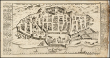
|
||

|

|
|

|
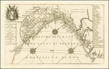
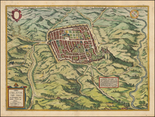
The First Modern Map of Italy
Stunning example of this important early map of Italy, which first appeared in the 1482 edition of the famed Ulm Ptolemy Geographia.
Drawn from the work of Dominus Nicolaus Germanus, a Benedictine monk from Saxony, this map is perhaps the single most important modern map of Italy published in the 15th Century and certainly the most beautiful.
Along with the map of Francesco Berlingheri also published in 1482 in Florence entitled Novella Italia, the present map holds the distinction of being the first modern map of Italy. It is also the first map to appear to be in its original color and the first published North of the Alps. This is one of the 5 modern maps (Italy, Spain, Palestine, France and Scandinavia) that had been added the the traditional set of 27 Ptolemy maps which appeared in the Ulm edition.
The present map differs significantly from Berlinghieri's map, most notably in the shape of Corsica and northern Sardinia and the different orientation of the two maps, which allows a "longer" treatment of the Italian peninsula, significantly less of the Adriatic Sea. A closer inspection of the two maps reveals that they are, remarkably, drawn from entirely different courses.
Sources
The Ulm Ptolemy map of 1482-86 derives from a map found in codex 2586 (a manuscript copy of Ptolemy’s Geographia), an example of Ptolemy's Geographia drawn by Dominus Nicolaus Germanus for Pope Paul II.
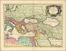
Comparing the modern map of Italy to Ptolemy's Sexta Europae Tabula, it quickly becomes apparent that the map is significantly improved in Northern Italy (most notably Italy's famous Alpine Lakes) and far more elaborate treatment of the Po River and its tributaries. The concept of a single Apennine mountain range has also evolved into a far more complex set of mountains and riverine watersheds.
The Ulm Ptolemy of 1482 and 1486
The Ulm edition of Ptolemy was first published in 1482 by Lienhart Holle. In contrast to the two earlier illustrated editions of Ptolemy's geography - Bologna (1477) and Rome (1478) - the maps in the Ulm edition are woodblock prints, not copperplate engravings. The maps in the Ulm edition follow the manuscript maps of Donnus Nicolaus Germanus, a Benedictine monk from Breslau who produced brilliant presentation copies for Italian elites in the 1460s and 1470s. Specifically, the Ulm was patterned after the manuscript atlas prepared for Pope Paul II. The Ulm Ptolemy was the first book Holle published, but it was also to be one of his last. Holle went bankrupt shortly after the original publication. The work was then taken over by Johann Reger, who issued another edition in 1486.
The differences between the two editions are relatively small. The 1486 maps typically include titles at the top, whereas there were no titles on the 1482 maps. An unpublished study of the individual maps reveals that there are multiple states of most of the maps.
It had long been suggested that the way to differentiate between the 1482 and 1486 editions was the use of lapis lazuli blue in the 1482 edition for the seas, whereas the 1486 used brown. However, the same unpublished study, which evaluated dozens of examples of the two editions, determined that the earliest examples of the 1486 were also issued with the lapis lazuli blue, suggesting that when Johann Reger acquired the woodblocks, he likely also acquired some unused lapis lazuli. In 2021, we offered for sale a complete example of a 1486 entirely in lapis lazuli blue.
Claudius Ptolemy (fl. AD 127-145) was an ancient geographer, astronomer, and mathematician. He is known today through translations and transcriptions of his work, but little is known about his life besides his residence in Alexandria.
Several of his works are still known today, although they have passed through several alterations and languages over the centuries. The Almagest, in thirteen books, discusses astronomy. It is in the Almagest that Ptolemy postulates his geocentric universe. His geometric ideas are contained in the Analemma, and his optical ideas were presented in five books known as the Optica.
His geographic and cartographic work was immensely influential. In the Planisphaerium, Ptolemy discusses the stereographic projection. Perhaps his best-known work is his Geographia, in eight books. However, Ptolemy’s ideas had been absent from western European intellectual history for roughly a thousand years, although Arab scholars interacted with his ideas from the ninth century onward.
In 1295, a Greek monk found a copy of Geographia in Constantinople; the emperor ordered a copy made and the Greek text began to circulate in eastern Europe. In 1393, a Byzantine diplomat brought a copy of the Geographia to Italy, where it was translated into Latin in 1406 and called the Cosmographia. The manuscript maps were first recorded in 1415. These manuscripts, of which there are over eighty extant today, are the descendants of Ptolemy’s work and a now-lost atlas consisting of a world map and 26 regional maps.
When Ptolemy’s work was re-introduced to Western scholarship, it proved radically influential for the understanding and appearance of maps. Ptolemy employs the concept of a graticule, uses latitude and longitude, and orients his maps to the north—concepts we take for granted today. The Geographia’s text is concerned with three main issues with regard to geography: the size and shape of the earth; map projection, i.e. how to represent the world’s curve proportionally on a plane surface; and the corruption of spatial data as it transfers from source to source. The text also contains instructions as to how to map the world on a globe or a plane surface, complete with the only set of geographic coordinates (8000 toponyms, 6400 with coordinates) to survive from the classical world.