|
||

|

|
|

|
"The First Printed Map of Scandinavia" - Ginsberg 1
"In the [1482 Ulm], printed ten years before the first voyage of Columbus, a map is given, embracing not only the North of the Old World, but also that part of the New world (Greenland), which, half a millennium before Columbus, was discovered by the Scandinavians." (Nordenskiöld)
"Because it is a first and because it has great visual appeal, the map of [Ulm Ptolemy] Scandinavia . . . is a cornerstone map for collectors." - Ginsberg, page 20.
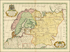
This superb 15th-century map, the first printed map of Scandinavia, was produced by Leinhart Holle for the famed Ulm Ptolemy Geographia 1482. Holle's source for the map is a manuscript map dawn by Donnus Nicolaus Germanus, a Benedictine monk who produced the map between about 1468 and 1471. The present example appeared in the Geographia, also published in Ulm by Johann Reger, who acquired the woodblocks from Holle prior to 1486.
The historical significance of this map extends beyond its pioneering representation of northern territories; it embodies the transition from medieval to modern cartography. As noted by Nordenskiöld in his famed Facsimile-Atlas, this map shows a part of the New World in the form of Greenland ("Engronelandt") a decade before Columbus ventured to the Americas. Moreover, the map includes the place name "Congelatum" for the northeastern most sea, a name typically associated with the Mare Congelatum or Oceanus Glacialis, both early names for the Arctic Sea.
The map features a representation of Scandinavia that would become characteristic of the earliest cartography of that region. Norway ("norbegia") is rendered with elaborate peninsulas and fjords. Oslo ("asto"), Bergen ("begensis"), Trondheim ("nodrosia"), and other cities are indicated and labeled. In Sweden ("Suetia que et gottia occidentalis"), two large lakes, presumably Lakes Vänern and Vättern, dominate the interior.
Off the west coast of Scandinavia, the Orkney and Faroe Islands are rendered under the general name Iperboreum (Hyperborea).
Iceland is depicted with a mountainous interior and six rivers running out from it. Ten Icelandic cities named and located.
States of the Map
There are two states of the map.
As noted by Ginsberg, there is no text on the verso of this map in either the 1482 or the 1486, and therefore the two states can only be differentiated by the printed title at the top, or lack thereof:
- State 1: (1482) No title
- State 2: (1486) Title added: Tabula Moderna Prussie, Livonie, Norvegie et Gottie
The Ulm Ptolemy of 1482 and 1486
The Ulm edition of Ptolemy was first published in 1482 by Lienhart Holle. In contrast to the two earlier illustrated editions of Ptolemy's geography - Bologna (1477) and Rome (1478) - the maps in the Ulm edition are woodblock prints, not copperplate engravings. The maps in the Ulm edition follow the manuscript maps of Donnus Nicolaus Germanus, a Benedictine monk from Breslau who produced brilliant presentation copies for Italian elites in the 1460s and 1470s. Specifically, the Ulm was patterned after the manuscript atlas prepared for Pope Paul II. The Ulm Ptolemy was the first book Holle published, but it was also to be one of his last. Holle went bankrupt shortly after the original publication. The work was then taken over by Johann Reger, who issued another edition in 1486.
The differences between the two editions are relatively small. The 1486 maps typically include titles at the top, whereas there were no titles on the 1482 maps. An unpublished study of the individual maps reveals that there are multiple states of most of the maps.
It had long been suggested that the way to differentiate between the 1482 and 1486 editions was the use of lapis lazuli blue in the 1482 edition for the seas, whereas the 1486 used brown. However, the same unpublished study, which evaluated dozens of examples of the two editions, determined that the earliest examples of the 1486 were also issued with the lapis lazuli blue, suggesting that when Johann Reger acquired the woodblocks, he likely also acquired some unused lapis lazuli. In 2021, we offered for sale a complete example of a 1486 entirely in lapis lazuli blue.
![[ Iceland ] Isola d'Islanda](https://storage.googleapis.com/raremaps/img/small/98962.jpg)