|
||

|

|
|

|
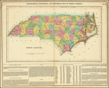
Rare Final State in Original Color
Striking example of Mathew Carey's map of North Carolina, one of the earliest large-format maps of the State after independence.
The present example was separately issued on thinner paper.
Includes the topography of North Carolina, as well as roads, towns, rivers, lakes, and a host of other details.
The map shows the growth of the State in the early 19th Century. Meticulous details shown to the inclusion of the growing road system in the State Courthouses, in each county, are noted, as are the major towns.
Mathew Carey issued his first folio atlas map of North Carolina in 1795. A second edition of the map was issued in 1814 and a third edition issued in about 1816. The editions can be identified a follows (year in parenthesis is first year published)
- 1st Edition / State 1 (1795): The State of North Carolina from the best Authorities by Samuel Lewis.
- 1st Edition / State 2 (1800): Page #37 added
- 2nd Edition / State 1 (1814): New plate. North Carolina. Title in swath letters. No County Borders Shown
- 2nd Edition / State 2 (1814): County Borders Added
- 3rd Edition / State 1 (1814-1816): New plate. North Carolina from the Latest Surveys by Samuel Lewis. Title in block letters. Craven County spelled C R A W E N
- 3rd Edition / State 2 (1818): Anson and Rutherford counties named; Craven County now correctly spelled
![Gray's New Map of North Carolina and South Carolina [Charleston Harbor Inset]](https://storage.googleapis.com/raremaps/img/small/98362.jpg)
![[First State?] Rand, McNally & Co's Indexed County Map of North Carolina . . . 1880](https://storage.googleapis.com/raremaps/img/small/87572.jpg)