|
||

|

|
|

|
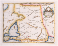
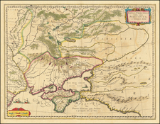
Very rare separately published map of the southern part of Ukraine, published by the Royal Academy in St. Petersburg.
The map provides a detailed account of the battles between the Russian and Turkish Armies. The map was later copied in Augsburg by Seutter, but this is the original, which includes a number of subtle differences.
The map illustrates the military operations by the Russian Imperial Army along the Don and Dnieper Rivers in 1736, a notable period during the Russo-Turkish Wars.
Key Translation and Contextualization:
A. Der Dnieper Strom - The Dnieper River: A vital geographical feature, illustrating the natural barrier and strategic route for military and trade activities in Eastern Europe.
B. Die Ukrainische Linie - The Ukrainian Line: Refers to the fortifications or demarcation lines in the Ukrainian territory, significant for its role in the defense strategies against the Ottoman Empire.
C. Der Donetz - The Donets River: Indicates another crucial waterway, highlighting its importance for logistical movements and as a natural defense line.
D. Der Donn - The Don River: A key strategic point, serving as a critical part of Russia’s southern defense and offense operations against the Ottomans.
E. Bachmuth. (alwo die Saltzwercke sind) - Bachmut (where the salt works are): Points to the city's economic and strategic importance due to its salt production.
F. Thor - Thor: Likely refers to a gate or fortification, symbolizing a point of defense or passage.
G. Der Marsch unserer Armee nach der Crim - The march of our army towards Crimea: Indicates the military path or strategy taken by Russian forces towards the Crimean Peninsula.
H. Grosser Weg welchen die kauf Leuthe aus der Ukrain nach der Crim nehmen, und welchen der Obriste Leitsch mit einem Comando nach der Setz gegangen - Main route taken by the traders from Ukraine to Crimea, and which Colonel Leitsch took with a command towards Setz: Illustrates both commercial routes and specific military maneuvers.
I. Die Saporogsche Setz - The Zaporizhian Sich: Refers to the stronghold of the Cossacks, playing a crucial role in the regional power dynamics and military alliances.
K. Die vier Haften in der Crim wo die Türcken landen - The four harbors in Crimea where the Turks land: Highlights the points of Ottoman incursions and the strategic maritime locales.
L. Weg von Asow bis Perecop am dem Ufer des Schwarzen Meeres, alwo man auf halben Weg das Proviant vom Donn nach Perecop bekommen kann - Route from Azov to Perekop along the coast of the Black Sea, where one can get provisions from the Don halfway to Perekop: Demonstrates logistical lines and the importance of the Black Sea coast in military supply chains.
M. Fahrt zu Wasser umb ums das Proviant vom Donn zu führen - Water journey to transport provisions from the Don: Indicates the utilization of riverine routes for the movement of supplies.
N. Verschiedene Anfürthen welche man suchen muß so dann ge unsere Fahrzeuge sich bis in die Crim nicht wagen könne - Various approaches that must be sought so then our vehicles cannot venture into Crimea: Suggests alternative routes or strategies due to the risks involved in direct engagements.
This map not only documents the logistical and strategic aspects of 18th-century military campaigns but also provides insights into the geographical understanding and territorial ambitions of the Russian Empire during this period. It encapsulates the intricate interplay between natural landscapes and human endeavors in the historical theatre of war.
![[ Lviv / Tarnow ] Des Koenigreichs Galizien und Lodomerien mittlere Kreise](https://storage.googleapis.com/raremaps/img/small/103315.jpg)