|
||

|

|
|

|
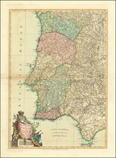
Isaak Tirion's map depicting the region from Lisbon to the Strait of Gibraltar, published in Amsterdam in 1759, is a fine example of 18th-century cartography.
The map includes a detailed representation of the southwestern coast of the Iberian Peninsula, including the cities and coasts of Portugal and southern Spain. It likely includes navigational details such as depth soundings and anchorage points.
Includes Lisbon, Cadiz ("Cadix"), Gibraltar, and Cueta.
The map is a testament to the Dutch expertise in cartography during this period, characterized by precise measurements and an aesthetic blend of utility and artistry.
Isaak Tirion was a prominent Dutch publisher based in Amsterdam in the eighteenth century. He is best known for historical works that included prints showing scenes from around the world. He also produced maps, such as those in the Nieuwe Hand-Atlas of 1744.
![[ Basque Harbors ] Kaarte over Pasages Havn / Kaart over Byen St. Sebastian og dens Havn / Kaart over Sudlobet til Bilbao / Havenen ved Santoña](https://storage.googleapis.com/raremaps/img/small/39054se.jpg)