|
||

|

|
|

|
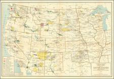
Early Coast to Coast Map of the United States
Highly detailed map of the United States from coast to coast.
The map is particularly notable for its comprehensive coverage of the Trans-Mississippi West, a feat not commonly achieved in maps of this period. This was a time when the United States was still exploring and asserting its presence in the Pacific Northwest, a region rich in fur resources that attracted the attention of American entrepreneurs like John Jacob Astor. Astor's efforts to establish Fort Astoria in 1811, aiming to monopolize the American Fur Trade, marked a significant phase in the commercial exploitation of these territories.
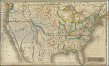
The historical context surrounding this map is deeply intertwined with the exploratory expeditions that preceded its creation. Lapie's work is informed by the pioneering journeys of Lewis and Clark (1804-1806), as well as the Astorian expeditions led by Wilson Price Hunt and Robert Stuart in 1811, which provided critical insights into the geography of the Pacific Northwest. Despite this, Lapie's map conspicuously omits the exploratory contributions of Stephen Harriman Long in the early 1820s and Jedediah Smith's significant findings beyond the Great Basin, indicating a selective incorporation of exploratory data.
The map includes an excellent 54-40 or fight Oregon Territorial Border, terrific post-Lewis & Clark, post-Zebulon Pike view of the Rocky Mountains and excellent treatment of the Southwest and Missouri Valley. The details of the Lewis & Clark and Hunt & Randel expeditions are in evidence. The two mythical rivers extending from Lakes Timpanogos and Teguayo to the Pacific Ocean are shown, based upon the lost Walker map.
The Rio Colorado is shown flowing south from the southwestern mountains and locating a number of early villages on its upper tributaries but trailing off without an outline of the Gulf of California.
The map shows several of the earliest emigrant trails through the west. In the north, a trail extends from the Missouri River just north of the Ouetarhou River westward, with a second trail beginning further up river just west of the Tour de Pompey (the point where Lewis and Clark separated), both which join in the Rocky Mountains and extend into Oregon Country and ultimately to the Columbia River and the Pacific Ocean, showing the route of the two explores.
In modern day Wyoming, a trail is shown extending from a camp on the North Fork of the Platte River. During fur-trade times in the 1820s and 1830s, many travelers crossed at Red Buttes, west of present Casper.
An excellent early coast to coast map of the US.

![United States Atlas [rolled]](https://storage.googleapis.com/raremaps/img/small/91367.jpg)