|
||

|

|
|

|
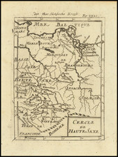
Upper Saxony, published by William Lizars in Edinburgh around 1828, stands as a striking cartographic representation of the region which now encompasses large parts of eastern Germany and western Poland. The map is colored to delineate distinct areas and showcases roads, towns, mountains, and other significant geographical features. Notably, regions such as Swedish Pomerania, Prussian Pomerania, the Mark of Brandenburg, the Margraviate of Meisen, Lusatia, and the Duchy of Silesia are presented, highlighting cities of importance such as Berlin and Leipzig.
The early 19th century was a period of political reshaping and territorial realignments in Central Europe. Following the Napoleonic Wars, the Congress of Vienna in 1815 saw significant territorial adjustments, resulting in the consolidation and rearrangement of many regions. The detailed depiction of Upper Saxony and its neighboring regions on this map mirrors the political landscape of the era and provides a window into the geopolitical significance of these territories.
William Lizars, renowned for his engraving prowess, has captured the topographical nuances and urban centers of Upper Saxony with commendable precision. The differentiation between regions through color assists in understanding the administrative divisions, revealing the complexities of governance and territoriality during this period. The inclusion of well-traveled roads and notable towns underscores the region's importance as a hub of trade, communication, and cultural interchange.
The representation of cities such as Berlin and Leipzig, pivotal centers of cultural and intellectual renaissance in the 19th century, adds another layer of significance to this map. These urban centers were not only political and administrative hubs but also played crucial roles in the socio-cultural evolution of Europe during the Romantic era, with Leipzig, for instance, establishing its reputation as a major European city of literature and arts.
The Lizars were a Scottish family of engravers and printers who produced many views and maps. Daniel Lizars Sr. (1754-1812) was the son of a shoemaker, but he apprenticed with Andrew Bell, a printer and engraver. Lizars set up his own printworks near St. Giles Cathedral and took on his own apprentices, including George Bartholomew, whose son John would go on to found the important mapmaking firm later know as John Bartholomew & Son Ltd.
Daniel Sr. had three sons: Daniel Jr., John, and William Home. He also had a daughter, Jane Home. Daniel Jr. (1793-1875), the youngest of the boys, apprenticed in his father’s shop alongside George Bartholomew. When his father died in 1812, Daniel Jr. took over much of the business, expanding it and specializing in maps. The company went bankrupt in 1832, however, and Daniel emigrated to Canada.
John Lizars (1792-1860), the middle son, studied medicine and became Professor of Surgery at the Royal College of Surgeons of Edinburgh, as well as senior surgeon at the Royal Infirmary of Edinburgh.
William Home Lizars (1788-1859), the eldest, also apprenticed in his father’s shop. After learning engraving, William entered the Trustees’ Academy to learn under John Graham. He was a skilled painter and artist. When his father died, and after his Daniel Jr. left, he carried on printing and invented a method of etching that looks like wood engraving.
![Повстанцы 1863 Года [(Polish) Insurgents of 1863]](https://storage.googleapis.com/raremaps/img/small/52719.jpg)
![[Gdansk]. Prospect, Grundris und Gegend der Polnischen velen Reichs und Handels=Stat Dantzig . . .](https://storage.googleapis.com/raremaps/img/small/35677.jpg)