


|
||

|

|
|

|
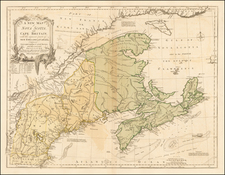
Early Mapping of the 1821-23 Explorations of the HMS Fury and HMS Hecla, led by William Edward Parry
Nice example of this rare 1825 edition of James Wyld's massive map of North America, including the extra panel at the bottom, adding Central America.
Wyld's map of North America was first issued in 1823. Between 1823 and the 1870s, the map was periodically revised and updated. An earlier state, issued in 1820 by Faden also exists, meaning that the history of the map spans six decades, almost certainly the single most enduring wall map of North America ever published.
For this 1825 state, Wyld has made significant improvements in the Polar regions, focused on the search for the Northwest Passage, primarily based upon the explorations of the HMS Fury and HMS Hecla, led by William Edward Parry, as reported in his Journal of a Second Voyage, &c . . . published in 1824. As can be seen from a comparison of this map to Wyld's 1823 state of the map, there are two major changes, the addition of the 7th sheet covering Central America and the significant improvements in the Polar regions. The most significant additions are in the area's labeled Cockburn Island and Melville Peninsula, neither of which appear on the 1823 map. The revisions begin in Hudson's Strait. with major changes to the coastal outlines, new islands, and a remapping of Southmapton Island. Wager's River, Repulse Bay and Foxe's Channel were extensively improved and mapped, with a number notes suggesting the information was received from the Esqimauxs.
James Wyld was one of the most prolific publishers of separately issued maps during the 19th Century. His wall map of North America is a testament to Wyld's publishing acumen. The present map reflects a marvelous mix of information derived from 2 of the most important maps of the period, John Melish's map of the United States (first issued in 1816 and periodically updated into the 1820s) and Aaron Arrowsmith's map of North America, first issued in 1796 and periodically updates into the early 1830s.
As noted by the title, Wyld works to incorporate the discoveries of numerous important explorers, covering explorations from the Polar regions (MacKenzie, Hearne, Ross, Parry & Franklin), early American explorers, including Lewis & Clark, Pike and Bouchette, coastal explorations by Vancouver, and the remarkable work of Humboldt.
Other explorations which are not mentioned by name in the map title are in evidence. From Arrowsmith, Wyld introduces the information from the Escalante-Dominguez expedition of 1777 which provided more information about the region between California and the Rocky Mountains than any other source up to John Fremont in the 1840s. Curiously, however, Wyld misspells Escalante's name (Velez Ascalante) and mentions a Father Antonio Velasquez (however Francisco Atanasio Domínguez was Escalante's partner on the expedition). The Domínguez–Escalante expedition was a Spanish expedition conducted in 1776 Domínguez and Escalante, seeking an overland route from Santa Fe, New Mexico to the mission in Monterey, California. Domínguez, Vélez de Escalante, and Bernardo de Miera y Pacheco, acting as the expedition's cartographer, traveled with ten men from Santa Fe through many unexplored portions of the American West, including present-day western Colorado, Utah, and northern Arizona. Along part of the journey, they were aided by three indigenous guides of the Timpanogos tribe (Shoshone or Ute people).
In the same area, Humboldt noted the legendary "First Settlemt. of the Azteques from Aztlan in 1160", with a second set of "Ruins of Houses, second settlement of the Azteques, from when they passed to Tarahumara & Hileicolbuacan (Culeican)."
Texas is shown on the eve of the arrival of Americans such as Stephen F. Austin. Pike's route is shown, with a note locating the place where La Salle landed and built Fort Matagorda. Further north the Haytones Villages, Wandering Ground and Hawa Wandering Range are noted, with a Pawnee Village further east on the Red River.
Further north, an exceptional treatment of the Northwest is given, incorporating the basic footprint left by Lewis & Clark, with significant improvements by the Hudson Bay Company, Northwest Company, and the American Fur Traders Hunt & Stuart, who first reported the Oregon Trail in 1821. Lewis & Clark's route is shown. The detail in Texas and the Transmississippi West reflects Wyld's attention to detail and synthesis of the best of Arrowsmith, Melish, Lewis & Clark, Pike, Long, and others.
The treatment of the Upper Midwest is also noteworthy in the early editions. Here, Michigan Territory is shown on both sides of Lake Michigan, sections of Michigan east of the lake marked as Michilmackinack District, Erie District and Huron District. There were 3 of 4 Civil Districts created on July 3, 1905 by Territorial Governor William Hull (along with th District of Detroit) as county precursors for administrative and judicial functions of the territorial government.
Illinois is pushed off of Lake Michigan (with Chicago in Michigan Territory, and Illinois extends far west of its true position. Massive Northwest Territory shown, with a triangular area marked as Carver's Grant shown on the Chippewa River and its tributaries (see below).
Crossing the Illinois-Northwest Territory boundary is a line marked as Indian Boundary Line, with further Indian boundary lines found in southern Illinois and southern Indiana.
The old Spanish colonies west of the Mississippi River are also still shown (St. Louis District, Cape Girardeau District, Howard District, Lawrence District Arkansas District), with roads reaching as far as St. Louis and St. Charles, Missouri and west of the Osage Boundary, which extends from near Ft. Clark on the Missouri River to the Red River just north of Coshattaville in modern day Texas.
Arkansas Territory extends to double its normal width, including all of the future Indian Territory (Oklahoma), including a massive Devallierre's Grant north of the Arkansas River.
Devallierre's Grant
These are the lands granted in 1793 by Baron de Carondelet, Governor of Louisiana, to Sir or Don Joseph Valliere. The size of the actual grant is disputed and the grant itself was not pursued and therefore deemed abandoned.
In 1793, a land grant was by Louisiana Governor Francisco Louis Hector Carondelet to Don Joseph Valliere. The grant, officially recorded by Carlos Trudeau, the Royal and Private Surveyor of the Province of Louisiana, includes a map pinpointing the land's location along the White River, now within the borders of Arkansas and Missouri, and is part of a small archive of documents sold by bookdealer Fred A. Rosenstock in 1975 to the Beinecke Library (Yale).
Don Joseph Valliere, a captain in the Spanish Army serving in Louisiana until his death in 1799, and Don Carlos de Villemont, were both commandants at Arkansas Post who received substantial land grants from the governor. These lands, however, went unoccupied and unsurveyed during their lifetimes. It was only decades later, long after their deaths, that Valliere's and de Villemont's heirs sought to claim the lands through lawsuits against the U.S. government in the 1840s, efforts which ultimately failed in 1847.
Carver's Grant
In the mid-18th century, British soldier Jonathan Carver was tasked with mapping the rivers of Wisconsin and Minnesota to facilitate the search for a Northwest passage. During his explorations in 1766, Carver ventured through the Fox-Wisconsin route, up the Mississippi and Minnesota rivers, and wintered with the Sioux Indians. His journey, which aimed to find a route to the Pacific, was cut short at Grand Portage due to a lack of supplies. Carver's subsequent memoir, published posthumously in 1778, made no mention of a land grant. However, the editor of the third edition of his travels later claimed that Carver had received a deed from Sioux chiefs for a vast tract of land in the upper Mississippi Valley, a claim that would spark controversy and legal battles for decades.
Carver's descendants, in 1804, petitioned the U.S. Congress for ownership rights to the land based on the alleged deed, which described a large triangular tract in northwestern Wisconsin and eastern Minnesota. Despite their efforts, Congress, after an investigation, concluded in 1823 that English law at the time prohibited such grants to individuals, Carver had never mentioned the grant in his lifetime, and local Sioux elders denied any knowledge of the chiefs or the deed. This decision did not deter speculators from attempting to sell "Carver's Grant" for many years thereafter. Modern scholarship has largely debunked the existence of the grant, attributing the claims to deceit and manipulation by Carver's heirs and their agents.
The History of the Faden/Wyld Map of North America
The evolution of Wyld's map of North America is truly fascinating and reflects Wyld's commercial savvy.
The map was periodically updated in the 1820s and 1830s. With the outbreak of the Mexican-American War in 1846, Wyld issued a special 4-sheet edition of the map (eliminating the top 2 sheets and the bottom central America sheet), with a new title ( Mexico the British Possessions in North America and the United States . . . 1846), which included a number of geographical revisions in the regions depicted and focused on the battlegrounds of the Mexican American War.
Following the resolution of the Mexican-American War, Wyld re-issued his map of North America, showing the boundaries as established by the Treaty of Guadalupe Hidalgo, and with significant updates in the polar region, Alaska and northern Canada.
David Rumsey notes:
The first edition [by Wyld], listed in Phillips but not by Stevens and Tree or Wheat [was published in 1823] . . . A large impressive map showing with great accuracy the recent discoveries in the north west passage, but wildly off in the American southwest - Wheat: "a large and beautiful map, excellent in all respects save for its southwestern geography." In the southwest, Wyld adds many mountain ranges that were purely speculative - probably just to fill in blank spaces in the map (unlike Arrowsmith). In northwestern Texas is a curious note on the topography of the area attributed to "Mellish" which is copied from a pre-1822 edition of his large map of the United States. Comparing this edition to the derived map of 1846, "Mexico, the British Possessions...," one sees many changes in the northern areas and few in the southwest. Stevens and Tree list editions of 1824, 1827/8, 1838, and 1851/56.
In 1849, with the discovery of Gold In California, Wyld again saw commercial opportunity. Wyld again issued a section of his 7-sheet map of North America, under the title The United States Of North America With Part of the British Possessions And Mexico . . . 1849. For this map, Wyld completely re-worked California and incorporated for the first time the information from John Fremont's seminal map of Oregon and Upper California. The following year, Wyld would again release a revised edition of his 7 sheet map of North America, retaining the changes made in the US Gold Rush map of 1849, but with additional updates in both the US and again in the northern sections of the larger North America map which had not been offered as part of the US Gold Rush map of 1849.
While we have not attempted a complete cataloging of all of the later editions, we note that Wyld issued editions of his map of North America in 1860 and again in 1875. We suspect, although we have not made the analysis, that some of the Civil War maps issued by Wyld during the early 1860s are probably again fragments of his larger map of North America.
In addition to the editions listed by Rumsey, we note editions identified by OCLC as having been published in 1854, in the 1860 and "1870s." The Rumsey collection also includes an 1875 edition of the map.
In December 2000, Sotheby's offered a map which would appear to be a Faden edition of this map, dated 1820 and described as follows:
North America-Faden, W. Map of North America from 20 degrees to 80 degrees north latitude exhibiting the recent discoveries, geographical and nautical. London: Willam Faden, 1820. Total dimensions if joined 1480 x 1650mm., large engraved wall-map in 6 sheets, original outline colour . . .
Rarity
Early examples of the map are quite rare.
This is the third example we have offered for sale (1992-2024).
James Wyld Sr. (1790-1836) was a British cartographer and one of Europe’s leading mapmakers. He made many contributions to cartography, including the introduction of lithography into map printing in 1812.
William Faden, another celebrated cartographer, passed down his mapmaking business to Wyld in 1823. The quality and quantity of Faden’s maps, combined with Wyld’s considerable skill, brought Wyld great prestige.
Wyld was named geographer to Kings George IV and William IV, as well as HRH the Duke of York. In 1825, he was elected an Associate of the Institution of Civil Engineers. He was one of the founding members of the Royal Geographical Society in 1830. Also in 1830, his son, James Wyld Jr., took over his publishing house. Wyld Sr. died of overwork on October 14, 1836.
James Wyld Jr. (1812-87) was a renowned cartographer in his own right and he successfully carried on his father’s business. He gained the title of Geographer to the Queen and H.R.H. Prince Albert. Punch (1850) described him in humorous cartographic terms, “If Mr. Wyld’s brain should be ever discovered (we will be bound he has a Map of it inside his hat), we should like to have a peep at it, for we have a suspicion that the two hemispheres must be printed, varnished, and glazed, exactly like a pair of globes.”
![[ French & Indian War Battle Plan--Louisbourg ]. Plan De Louisbourg...](https://storage.googleapis.com/raremaps/img/small/57192.jpg)
![Le Colonie Unite Dell' America Settentrle. Di Nuova Projezione a S.S.E.E. Li Signori Riformatori Dello Studio Di Padovia . . . 1778 [12 sheets]](https://storage.googleapis.com/raremaps/img/small/90539.jpg)
![Louisiana [Large-Paper Example]](https://storage.googleapis.com/raremaps/img/small/83278.jpg)