


|
||

|

|
|

|
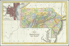
Detailed 19th-century thematic map of Pennsylvania, created to illustrate the distribution of iron ore within the state.
Created by Thomas C. Porter, a professor of botany at Lafayette College in Easton, PA, the map likely served an educational or resource management function. The map details the topography of Pennsylvania with shaded relief to illustrate mountain ranges, valleys, and plateaus, which is typical of the period's cartographic style.
Key features, such as rivers and towns, are marked, and areas with known iron ore deposits are likely highlighted or shaded differently to indicate their distribution. The color coding or shading would have been an important aspect of the map, allowing for quick visual identification of resource-rich areas.
![[Revolutionary War Plans of New York, Boston, Charleston, Delaware River to Philadelphia & Havana] Various Plans and Draughts of Cities, Towns, Harbours &c . . .](https://storage.googleapis.com/raremaps/img/small/83450.jpg)
![For Governor, Maj. Gen. John W. Geary [Former Mayor of San Francisco / Governor of Kansas Territory and Governor of Pennsylvania]](https://storage.googleapis.com/raremaps/img/small/93592.jpg)
![(Early Philadelphia Architectural Drawings) Plan of the ceiling of St. Andrews Church [with two additional drawings on another sheet]](https://storage.googleapis.com/raremaps/img/small/90443.jpg)