|
||

|

|
|

|
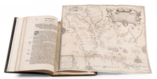
Early Appearance of South Australia and Swann River Colony in Australia
Unrecorded Final State with Major Revisions
Full original wash color example of this stunning wall map of Asia and Australia, published by John Cary.
First issued in about 1831, John Cary's wall map of Asia and Australia continues the tradition of exceptionally well researched British wall maps from the late 18th and early 19th Centuries. The 1820s and 1830s were a period of flux in the trade, with patriarchs such as Aaron Arrowsmith and William Faden giving way to their successors (Samuel and John Arrowsmith and James Wyld).
The present map expands the traditional coverage of Asia southward to Australia, capturing most of the continent, as well as a partial mapping of New Caledonia and the Loyalty Islands further to the east. First issued in 1831, this previously unrecorded 1838 edition dramatically improves the mapping of Australia and adds a defined South Australia (established in 1836) for the first time. Generally speaking, the entirety of Australia has been significantly improved in all respects. The most dramatic improvements include:
- Addition of Mitchell's explorations on the Murray River, etc.
- Addition of South Australia
- Addition of Swann River Colony, Perth, etc.
- Addition of Princess Charlotte Bay
- Improved mapping of the Coast of Arnhem Land
- Improved Mapping of The Coast of Western Australia
- Completion of the mapping of Exmouth Gulf and the Northwest Cape area
- Revised mapping of Shark Bay
- Significantly revised information in the interior of New South Wales.
Rarity
The map is of the utmost rarity on the market. We note a single example of the 1834 edition offered for sale in 2006.
We note an example in the National Library of Australia (1831), British Library (1831) and a private collection (1834).
A smaller 2 sheet version of the map was issued in 1828 and reprinted in 1832 (British Library and Oxford University).
John Cary (1755-1835) was a British cartographer and publisher best known for his clean engraving and distinct style which influenced the entire map industry. Born in Wiltshire, John was apprenticed to an engraver in London. He started his own business by 1782 and moved to several premises before settling at 86 St James’s Street in 1820.
Cary had several significant collaborations during his career. John Wallis and Cary diversified Cary’s business to include broader publishing projects. Brother William and John made globes together, while brother Francis participated in the company’s engraving work. Finally, geologist William Smith and Cary developed and sold geological maps, some of the first of their kind. The pair also produced a notable series of county maps starting in 1819. Cary’s atlases, of English counties and the world, were the standard texts of the early nineteenth century. He was appointed surveyor of roads to the General Post Office in 1794, which led to the New Itinerary, first published in 1798.
John trained his son, George, in engraving and George and his other son, John Jr., took over the business in 1821. It was then known as G. and J. Cary and continued in trade until 1850. The firm’s materials were then acquired by George Frederick Cruchley and then Gall and Inglis. By the time John died in 1835, Cary was the authoritative name in private map publishing and his business was a leader in the field throughout the first half of the nineteenth century.
![(Rare Czech Edition!) [Asia Secunda Pars Terrae in Forma Pegasi] [Asia in the Form of Pegasus]](https://storage.googleapis.com/raremaps/img/small/95830.jpg)
![ПОЛИТИЧЕСКАЯ КАРТА Азии [Political Map of Asia]](https://storage.googleapis.com/raremaps/img/small/90255.jpg)