


|
||

|

|
|

|
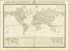
A Remarkable Wall Map of the World
From the Original Sea of the West to Cook and Von Stählin
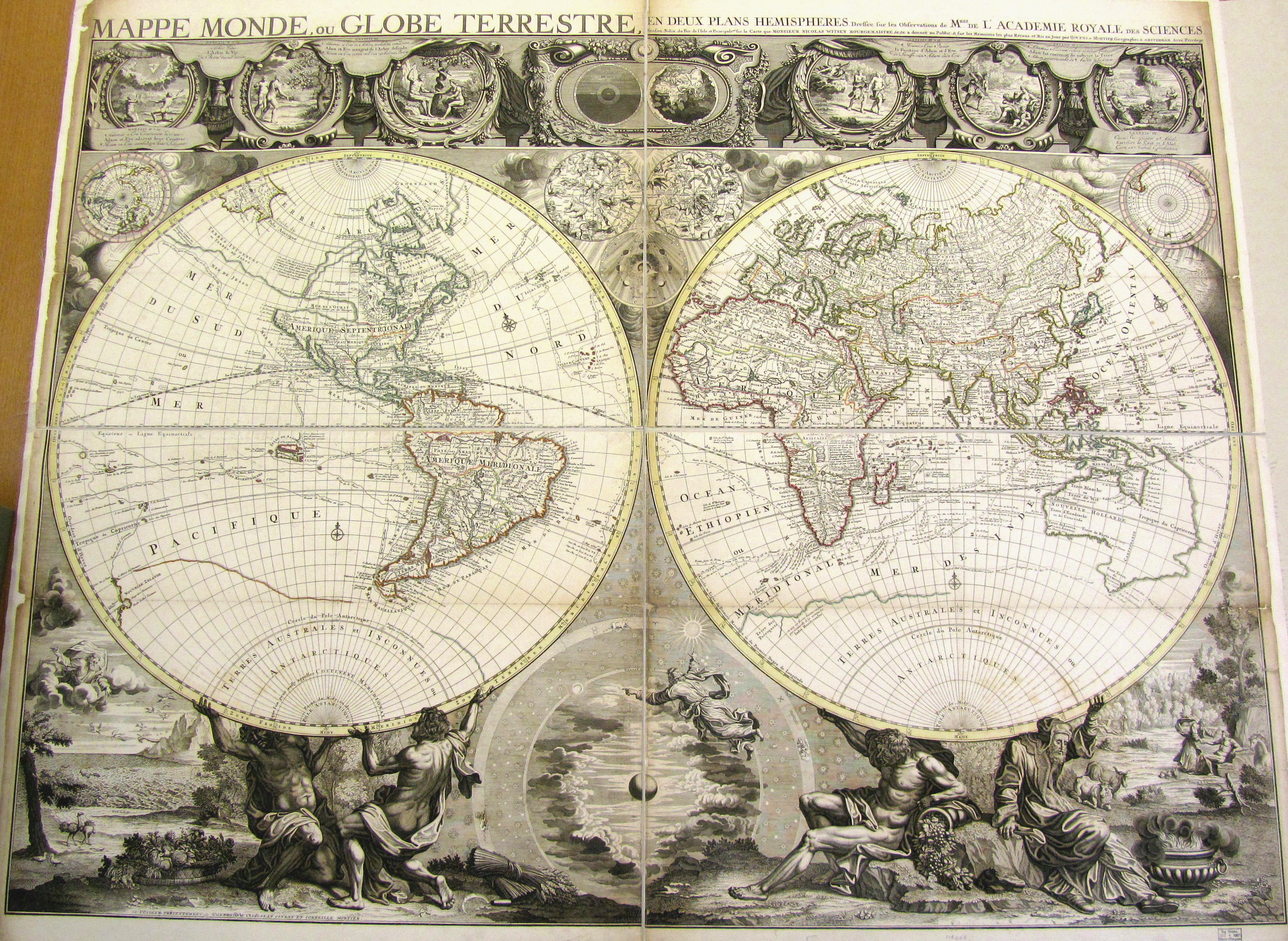
Extremely rare wall map of the World, based upon Jean Baptiste Nolin's banned world map of circa 1700, here offered in a very rare late state, with cartographic improvements to about 1774.
This remarkable 4 sheet map of the world is one of only two wall maps to illustrate the Sea of the West at the end of the 17th Century, the other being J.B. Nolin's map, which would almost immediately be banned from publication as a result of a dispute with Guillaume Delisle, from whom the cartographic depiction of the Sea of the West hand been "stolen."
Remarkably, Pierre Mortier and later Covens & Mortier were able to publish this map in Amsterdam, despite the ban on the Nolin edition, although circumstantially, the rarity of this wall map suggests that the ban on publication may have impacted this firm as well. Don McGuirk, in his work on the Sea of the West, identified only 1 tentative location for the first state of the map, suggesting that the copper plates may have gone unused for decades. Yet curiously, the map was revised several times to show significant cartographic improvements, all the while retaining the Sea of the West. This is made all the more curious by the fact that depictions of the Sea of the West ceased to exist until was reintroduced by Philippe Buache in 1752. The re-introduction of the sea was the result of Buache's review of his father-in-law's papers. Although Guillaume Delisle never published a printed map showing the sea of the west, he had postulated that it could exist. He said, the Sea of the West "was one of my discoveries. But since it is not always appropriate to publish what one knows or what one thinks one knows, I have not had this sea engraved on the works that I made public, not wanting foreigners to profit from this discovery" (as translated and quoted in Pedley, 109). The myth would persist in popular maps from 1752 until the publication of the results of James Cook's Third Voyage in the 1780s.
The present example of the map includes updates to about 1774, with significant improvements and revisions to the cartographic content, yet remarkably retaining the original Sea of the West configuration, which was again in vogue. Significant cartographic improvements in this 4th state include:
- New Zealand configuration, based upon Cook's first voyage.
- Significantly revised east of coast of Australia, based upon Cook's visit in the Spring and Summer of 1770.
- Australia no lionger attached to Papua New Guinea.
- Updated information based upon the Russian discoveries in the North Pacific and Alaska reported by Jacob von Stählin in 1773, including a reference to Satchan Nitada.
- Beginnings of the Coast of Alaska shown.
- Coastline connecting North America and Asia is removed west of the Strait of Anian.
- Elimination of the Salomon Islands discovered by Mendonna in 1566, just below the equator.
Satchtan Nitada
The toponym Sachtan Nitada, featured on 18th-century maps of the Northern Pacific Ocean, was first introduced by Jacob von Stählin in 1773, based on the findings of Lieutenant Ivan Synd. Synd, a veteran of the Second Kamchatka Expedition, led a voyage to the Bering Sea in 1764 to search for the Northwest Passage and to determine the nature of western Alaska's geography.
Synd’s expedition produced a map depicting a series of islands near Kamchatka, suggesting an archipelago rather than a peninsula. Stählin included Sachtan Nitada on the North American mainland near the Arctic Circle, marking it as a significant location from Synd’s explorations. This toponym supposedly denotes a place where Synd landed, near the 1730 Russian sighting of the Alaskan mainland.
The inclusion of Sachtan Nitada in Stählin’s map drew significant attention from the scientific community, leading to its rapid translation into English by the Royal Society of London by the end of 1774. The map and its accompanying book also circulated in French scholarly circles, further spreading knowledge of this remote region.
Nolin's Banned World Map
Jean Baptiste Nolin's world map, while groundbreaking, resulted in a five-year-long legal battle between Guillaume Delisle and Nolin over accusations of plagiarism.
Jean-Baptiste Nolin (1657-1708) came to his trade through his family; his father was an engraver, as was his brother. But J. B. Nolin alone gained real success in the pursuit. His close association with Vincenzo Maria Coronelli, which he cultivated while working in Rome in the 1670s, led to him being granted a monopoly on the distribution of the latter's work in France in 1686. This helped considerably in establishing Nolin as one of the leading cartographic publishers of seventeenth-century France. By 1694, Nolin was geographer to the Duke of Orléans, brother of Louis XIV. After the Duke's death in 1701, Nolin was appointed géographe du roi.
Shirley (map 650) called Nolin's world map "one of the finest large-scale world maps to be produced and [...] a fitting bridge between the geographical and artistic skills of the seventeenth century and the century to come." In fact, Shirley discovered what was previously the only known complete copy of the original 1700 issue at the Bibliothèque nationale de France in 1976.
Aside from its rarity, Nolin's wall map of the world deserves several monumental accolades:
- It is the first world map to begin the process of undoing the island of California myth, rendering it as a peninsula instead.
- It is the first world map to show the myth of the Sea of the West.
- It is the first world map to show a speculative eastern coast of Australia.
- It is the first world map to show the beginning of permanent French colonization of Louisiana ("Fort de Pontchartrain Col Françoise en 1699.")
There is only one problem with Nolin's map ... all of these cartographic innovations were plagiarized by Nolin from a manuscript globe made by the other leading force in French cartography, Guillaume Delisle.
The theft did not go unnoticed by Delisle, and it resulted in a five-year-long legal battle between the two mapmakers. The affair is covered in detail in several places, namely Numa Broc's 1970 article "Une affair de plagiat cartographique e sous Louis XIV : le procès Delisle-Nolin" in Revue d'histoire des sciences et de leurs applications and in Mary Pedley’s important The Commerce of Cartography (2005). On March 8, 1700, Delisle accused Nolin (at first not naming him) of having copied proprietary cartographic information from a manuscript globe that he had made for Chancellor Boucherat, which resided in the cabinet of the latter's son. This globe included information that Delisle had intentionally not put in print, such as the Sea of the West, because, according to De L'Isle himself, he did not want to make it available to France's competition. De L’Isle wrote of the Sea of the West:
It "was one of my discoveries. But since it is not always appropriate to publish what one knows or what one thinks one knows, I have not had this sea engraved on the works that I made public, not wanting foreigners to profit from this discovery" (as quoted in Pedley, 109).
Delisle's claim was complicated by the fact that Nolin had beaten him to market by four months— the first piece of evidence that Nolin used to defend himself. As it was a technical matter, the judges overseeing the case relied on the input of experts such as Sauveur, Chevalier, Cassini the Younger, and Maraldi. The panel of experts concluded that while Delisle was cogent in his responses to their questioning, Nolin was not:
"The Sieur Nolin, on the contrary, did not seem to us to be sufficiently educated to make use of these memoirs... it seems almost everywhere that he is ignorant... of the first principles of geography." (translated from a quote in Broc, pg. 148)
As this legal process was underway, Louis XIV published a new regulation on December 16, 1704 requiring geographers to submit all new maps to a commission of experts, to avoid counterfeiting. This is noteworthy for the present atlas, as it was almost certainly produced in 1704 with the intention of presenting it to the King.
On June 13, 1706, the Commission ruled in favor of Delisle, stating that Nolin had plagiarized the former's work, and as a result, was to have the copperplates for the world map put to the pestle (i.e., burnished of their cartography), to pay fifty livres in damages for slandering Delisle, and to have his brass instruments destroyed. De L'Isle showed magnanimity in not requiring the last of the punishments to be carried out. Still the process took a toll on Nolin, and he died two years later, in 1708, at the age of 51.
Despite its controversial origins, Nolin's world map was fantastically engraved (Nolin's real strong suit) and most importantly was the first printed map to publicize a host of cartographic revelations that Delisle had previously deemed state secrets and therefore kept private. With that being said, it is worth dwelling on a few aspects of the map's revolutionary cartography.
States of the Map Mortier / Covens & Mortier Wall Map and Rarity
This wall map, while known in 4 states, is exceedingly rare, with only a few surviving examples recorded.
Don McGuirk, in his exceptional survey of the maps of the Sea of the West, identified 4 states of the map.
- State 1: Pierre Mortier (circa 1703). Under title, upper right, "par PIERRE MORTIER Geographe A AMSTERDAM Avec".
- State 2. Covens & Mortier (circa 1721). Upper right under title now reads, "Par Covens et MORTIER Geographes A Amsterdam Avec Privilege". Now noted, lower left, "SE VENDENT PRÉSENTEMENT ... A AMSTERDAM, Chez JEAN COVENS ET CORNEILLE MORTIER."
- State 3. Covens & Mortier (circa 1735): Includes a single outline for New Zealand and pre-dates Cook's discoveries in New Zealand and Australia. We note examples at the Library of Congress and Bibliotheque National de France.
- State 4. Now with additional North American coastline across from Eastern Asia. This state was published after the completion of Captain James Cook's first voyage and including information and cartographic improvments for Australia and New Zealand from Cook. We note an example at the New York Public Library and at the Het Scheepvaart Museum in the Netherlands.
McGuirk's census of known examples identified 9 surviving examples in total across all 4 states of the map.
Many European maps of North America in the eighteenth century depict a large, western inland sea, hundreds of miles in diameter, with a small inlet to the Pacific and even some interior islands. The origins of this myth can be traced to several different sources and are tied to the search for a Northwest Passage. Like many cartographic myths, the Sea of the West persisted for decades, even in the face of strong evidence pointing to its non-existence.
One of the first European navigators to supposedly explore this area was Martin Aguilar. A Spanish captain, he sailed with Sebastian Vizcaino on a reconnaissance expedition up the California coast in 1602-3. Aguilar, commanding the Tres Reyes, was blown off course, to the north. When the seas calmed, Aguilar reported that he had found the mouth of a large river. Eighteenth-century geographers later conjectured that the river was the entrance to the Sea of the West.
Other maps placed the entrance to the Sea of the West via the Juan de Fuca Strait. Juan de la Fuca is the Castilianized name of Greek navigator Ioánnis Fokás (Phokás). Little archival evidence survives of Fuca’s career, but a chance meeting with an English financier, Michael Lok, in Venice in 1596 gave birth to rumors of Fuca’s voyages in the Pacific. Fuca reported that he had been sent north from New Spain twice in 1592 in search of the Strait of Anian. The Spanish Crown failed to reward Fuca’s discovery of an opening in the coast at roughly 47° N latitude and Fuca left the Spanish service embittered. His story lived on in Lok’s letters and eventually was published in Samuel Purchas’ travel collection of 1625. On many eighteenth-century maps, Fuca’s Strait is linked with a River or Sea of the West. In 1787, the present-day Juan de Fuca Strait was named by the wife of naval explorer Charles William Barkley, making permanent a label that had previously just been hopeful guesswork.
The source of the modern (18th Century) myth of the Sea or Bay of the West (Baye ou Mer de L'Ouest in French), are manuscript maps by Guillaume De L'Isle, who served as the Royal Geographer to the King of France at the end of the 17th Century and beginning of the 18th Century and is widely regarded as the most important map maker of his time. There is a map in Yale's map collection, which depicts a 16th Century Thames school map of North America with a large, "Branch of the South Sea," which closely resembles De L'Isle's Mer de L'Ouest, and may well be the source of De L'Isle's idea.
At the end of the 17th Century, Guillaume De L'Isle had access to the best available maps of the interior of North America, which were being provided from a number of missionary sources, as the French Missionaries pushed west of the Great Lakes and the Mississippi River and obtained information from the indigenous Indian tribes. De L'Isle was regularly producing and updating his manuscript maps in an attempt to integrate new and often conflicting information and improve upon the existing maps of North America. Many of his maps can be viewed as drafts, which were discarded in favor of other and considerably different models.
There are several De L'Isle manuscripts in the Bibliotheque Nationale de France, prepared as early as 1696 (dated), that depict this cartographic myth. Interestingly, while De L'Isle was a prolific publisher of printed maps, he never depicted the Sea or Bay of the West on any of his printed maps, which strongly suggests that he was not able to reconcile this information with the best available source information from America. During this same period, Jean Baptiste Nolin, who had in the prior decade collaborated with Vincenzo Maria Coronelli on his monumental globe for Louis XIV and produced a series of highly important maps of North America and its regions, would have also had access to many of the same reports and maps as De L'Isle. Nolin apparently gave greater credence to the concept than De L'Isle.
The earliest printed map to show the Bay of the West is Jean Baptiste Nolin's rare wall map of the world, published in about 1700. Nolin plagiarized the idea from Guillaume De L'Isle, as he testified when suing Nolin for plagiarism. He said, the Sea of the West “was one of my discoveries. But since it is not always appropriate to publish what one knows or what one thinks one knows, I have not had this sea engraved on the works that I made public, not wanting foreigners to profit from this discovery” (as quoted in Pedley, The Commerce of Cartography, 109). The court sided with De L'Isle and issued an order requiring Nolin to destroy the copper plates for the map (see Shirley 605). Nolin's map was in turn copied by the Mortier family, who issued 3 world maps shortly thereafter, showing Nolin's version of the Sea of the West, but the myth ignored for nearly half a century.
While the myth of the Sea or Bay of the West temporarily languished, the proliferation of Russian exploration off the Northwest Coast of America after 1740, as reported by Guillaume's younger brother Joseph Nicholas De L'Isle, reinvigorated interest in the region and forced the most prominent map makers of the period to re-examine existing knowledge. Joseph Nicolas served as a geographer to the Russian Academy and returned with this information to Paris. The re-introduction of the sea in the mid-eighteenth century was the result of Guillaume De L’Isle’s son-in-law, Philippe Buache’s review of his father-in-law’s papers. Although Guilluame De L’Isle never published a printed map showing the sea, he had postulated that it could exist, and that it might connect to a Northwest Passage through New France, not through English territory farther north.
The sea was a major part of Buache and Joseph-Nicholas Delisle’s maps of the North Pacific, published in the 1750s. While controversial, the features of those maps were quickly copied by other mapmakers, including the Sea of the West. The inland body of water lingered on maps until the later-eighteenth century.
During a period between 1750 and 1770, the most prominent French and British map makers advanced multiple and widely varying theories on the Northwest Coast of America. Denis Diderot dedicates several of the 10 maps in his monumental Encylopedie (1779 and after), to a comprehensive survey of the maps proffered by Joseph Nicholas De L'Isle (Guillaume's brother), Philippe Buache, Thomas Jefferys and others. The debate ended with Captain James Cook's and later George Vancouver and Comte Jean de la Perouse's explorations in the late 18th Century.
Johannes Covens (1697-1774) was a Dutch geographic publisher based in Amsterdam. He is best known for his collaboration with fellow publisher Cornelis Mortier (1699-1783). Pierre Mortier the Elder (1661-1711) had obtained a privilege in 1690 to distribute the works of French geographers in the Netherlands. After his widow continued the business for several years, Cornelis took over in 1719.
In 1721, Mortier forged a partnership with Covens, who had recently married Cornelis’ sister. They published under the joint name of Covens & Mortier. In 1774, upon the death of his father, Johannes Covens II (1722-1794) took over his father’s share. In 1778, the company changed its name to J. Covens & Zoon, or J. Covens & son.
Covens II’s son, Cornelis (1764-1825), later inherited the business and brought Petrus Mortier IV back into the fold. Petrus was the great-grandson of Petrus Mortier I. From 1794, the business was called Mortier, Covens & Zoon, or Mortier, Covens, & Son.
The business specialized in publishing French geographers including Deslisle, Jaillot, and Sanson. They also published atlases, for example a 1725 reissue of Frederik de Wit’s Atlas Major and an atlas, with additions, from the works of Guillaume Delisle. There were also Covens & Mortier pocket atlases and town atlases. The company profited from acquiring plates from other geographers as well. For example, the purchased Pieter van der Aa’s plates in 1730. Finally, they also compiled a few maps in house. At their height, they had the largest collection of geographic prints ever assembled in Amsterdam.
Cornelis Mortier (1699-1783) was a Dutch publisher who specialized in geography. Cornelis’ father, Pierre Mortier the Elder (1661-1711), had obtained a privilege in 1690 to distribute the works of French geographers in the Netherlands. After his widow continued the business for several years, Cornelis took over in 1719.
In 1721, Mortier forged a partnership with Johannes Covens, who had recently married Cornelis’ sister. They published under the joint name of Covens & Mortier. Their firm was one of the largest and most successful in Dutch history and continued in business until the late-nineteenth century.
In 1774, upon the death of his father, Johannes Covens II (1722-1794) took over his father’s share. In 1778, the company changed its name to J. Covens & Zoon, or J. Covens & Son. Covens II’s son, Cornelis (1764-1825), later inherited the business and brought Petrus Mortier IV back into the fold. Petrus was the great-grandson of Petrus Mortier I. From 1794, the business was called Mortier, Covens & Zoon, or Mortier, Covens, & Son.
The business specialized in publishing French geographers including Deslisle, Jaillot, and Sanson. They also published atlases, for example a 1725 reissue of Frederik de Wit’s Atlas Major and an atlas, with additions, from the works of Guillaume Delisle. There were also Covens & Mortier pocket atlases and town atlases. The company profited from acquiring plates from other geographers as well. For example, the purchased Pieter van der Aa’s plates in 1730. Finally, they also compiled a few maps in house. At their height, they had the largest collection of geographic prints ever assembled in Amsterdam.
![Western Hemisphere [and] Eastern Hemisphere](https://storage.googleapis.com/raremaps/img/small/77831.jpg)
![[ World Fur Trade ] Ubersichtskarte der Herkunftslander der hauptsachlichsten Luxus Pelztiere fur die Kurschnerei.](https://storage.googleapis.com/raremaps/img/small/103369.jpg)