|
||

|

|
|

|
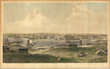
An Early Birdseye View of Augusta -- Capital of the State of Maine
Striking 19th Century birdseye view of Augusta, Maine, drawn by Albert Ruger, published in Madison by J.J. Stoner, with lithography by Beck & Pauli.
The key at the bottom locates roughly 4 points of interest, which are keyed with numbers and letters.
The non-native American history of Augusta, Maine begins in September 1607, when English explorers from the Popham Colony first arrived, marking the region's initial European exploration. This was followed by the establishment of a trading post by the Plymouth Colony Pilgrims in 1628, which was subsequently sold to four Boston merchants in 1661. The area experienced growth but was abandoned around 1676 due to the escalating conflict known as King Philip's War.
Re-settlement efforts were delayed until the mid-18th century when descendants of the original Boston merchants, known as the Kennebec Proprietors, reclaimed the land. They established Fort Western in 1754, which remained garrisoned until 1767. The fort's commander, James Howard, later purchased the property. Early settlers of this period included families such as Cony, North, and Sewall.
Augusta's official establishment as a distinct community occurred when it was incorporated as part of Hallowell in 1771, before breaking off to become Harrington in February 1797, only to be renamed Augusta later that year in honor of Pamela Augusta Dearborn. In 1799, it was designated as the county seat for the newly created Kennebec County. Augusta’s status was elevated further when it was chosen over Portland, Brunswick, and Hallowell to become the state capital of Maine in 1827, a decision solidified with the completion of the Maine State House, designed by Charles Bulfinch, in 1832.
The city saw significant development in the late 18th and throughout the 19th century, marked by the construction of key infrastructure such as the first bridge over the Kennebec River in 1797, and cultural advancements with the establishment of its first newspaper, The Intelligence, in 1795. The industrial era saw the erection of the Kennebec Arsenal between 1827-1835 and the expansion of various industries, notably lumber and textiles. The city was incorporated in 1849, with Alfred Redington serving as its first mayor in 1850.
Augusta's growth continued with the construction of infrastructure like the Kennebec Dam, introduction of the steamboat line in 1823, and the arrival of railroad service in 1852. The latter half of the 19th century saw the city recovering from the 1865 fire with new brick and granite structures and benefiting from an influx of Irish and French-Canadian immigrants contributing to the local workforce.
Following the Civil War, Augusta boomed as a community. The industrial sector in Augusta expanded significantly during this time. The establishment and growth of mills, particularly those related to lumber, grist, textiles, and paper, marked the city's landscape and economy. These industries not only provided employment but also contributed to Augusta's economic prosperity and attracted a workforce, including Irish and French-Canadian immigrants, adding to the city's cultural diversity.
Rarity
The view is rare on the market.
OCLC locates 2 copies: Library of Congress and University of Southern Maine.
The following is excerpted from the Library of Congrss Website:
Albert Ruger was the first to achieve success as a panoramic artist. The collections of the Library's Geography and Map Division contain 213 city maps drawn or published by Ruger or by Ruger & Stoner. The majority came from Ruger's personal collection, which the Library purchased in 1941 from John Ramsey of Canton, Ohio. Before this accession, there were only four Ruger city plans in the Geography and Map Division. Born in Prussia in 1829, Ruger emigrated to the United States and worked initially as a mason. While serving with the Ohio Volunteers during the Civil War, he drew views of Union campsites, among them Camp Chase in Ohio and Stephenson's Depot in Virginia. He continued to draw after the war, and his prints include a famous lithograph of Lincoln's funeral car passing the statehouse in Columbus, Ohio.
By 1866, Ruger had settled in Battle Creek, Michigan, where he began his prolific panoramic mapping career by sketching Michigan cities. Full descriptions of many Ruger views of Michigan cities are contained in John Cumming's A Preliminary Checklist of 19th Century Lithographs of Michigan Cities and Towns. Urban communities in some twenty-two states and Canada, ranging from New Hampshire to Minnesota and south to Georgia and Alabama, were sketched by Ruger. He continued his activity into the 1890s, moving his business to Chicago, Madison, and St. Louis as he sought new markets. In the late 1860s, Ruger formed a partnership with J. J. Stoner of Madison, Wisconsin, and together they published numerous city panoramas. Ruger was particularly productive during the 1860s; in 1869 alone, he produced more than sixty panoramic maps. In addition to city plans, he drew views of university campuses, among them Notre Dame, Shurtleff College, and the University of Michigan. Albert Ruger died in Akron, Ohio, on November 12, 1899.