|
||

|

|
|

|
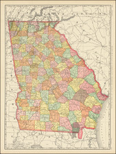
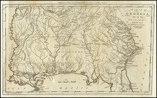
Georgia Before Georgia
A Landmark of American Utopian Urban Planning.
Sir Robert Montgomery's plan of Azilia offers a captivating glimpse into the early English aspirations of establishing a colony in the untamed wilderness of what would later become the state of Georgia. This map, produced during an era of colonial expansion and geopolitical intrigue, unveils Montgomery's grand scheme to create a fortified "Margravate of Azilia," generally intended as a protective buffer for Carolina against Spanish Florida and the Creek Nation. The colony was to be set within the vast tract of land stretching from the Savannah to the Altamaha rivers.
This engraved folding plan represents the intricate layout of the Margravate. At its core lies the resplendent Palace of the Margrave, radiating authority and dominion over four planned townships, each composed of 29 landed estates with game parks at their center, the whole encompassed by an imposing 80-mile-long fortified perimeter. This remarkable design envisions a feudal colony dedicated to the cultivation of exotic commodities such as silk, tea, coffee, almonds, and other luxuries typically imported from the Mediterranean and the Far East.
Montgomery's dream of the Margravate of Azilia remained unfulfilled due to a lack of sufficient investors and perhaps the impact of the Yamasee Indian War (1715-1717). Although it never materialized as he envisioned, the legacy of Azilia persists on some later maps of Carolina and North America, serving as a testament to the audacious aspirations of colonial-era visionaries like Montgomery.