![[Lithuania & Poland] Novissima et accuratissima Magni Ducatus Lithuaniae in suos Palatinaus et Castellanias divisae Delineatio . . . By Matthaus Seutter](https://storage.googleapis.com/raremaps/img/small/63449.jpg)


|
||

|

|
|

|
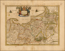
Fine example of Lotter's map of Lithuania and parts of Poland, Belarus and Ukraine.
A highly detailed map of Lithuania, showing towns, castles, Palatinates, rivers, lakes, forests, etc.
The map shows the region shortly after the conclusion of the Great Northern War (1700-1721). During this time, the Russian army invaded Lithuania, causing significant damage to the country and weakening its power. The war ended with the Treaty of Nystad in 1721, which ceded parts of Lithuania to Russia and limited the political independence of the country.
Tobias Conrad Lotter (1717-1777) is one of the best-known German mapmakers of the eighteenth century. He engraved many of the maps published by Matthaus Seutter, to whose daughter Lotter was married. He took over Seutter’s business in 1756. Lotter’s son, M. A. Lotter, succeeded his father in the business.
![Hanc Ger[maniae et P]oloniae de[s ... ]em Serenissim [P]otentissimi Poloniae Regi August offert et inscribit Petrus Schenck](https://storage.googleapis.com/raremaps/img/small/64898.jpg)