


|
||

|

|
|

|
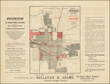
Murrieta's Planned California Southern Railroad Depot and Grounds
Rare hand drawn map of a portion of Murietta, California, illustrating the area around the planned California Southern Railroad Depot and Grounds.
The present map, drawn in late 1886 and recorded in early 1887, was part of the construction of the California Southern Railroad's Depot, California, which would catalyze the birth of the modern town of Murietta.
Oriented with northwest at the top, the map shows what is now the heart of Murietta, centered on intersection of New Clay Street and Juniper Street. The Depot Grounds are now the location of the Second Murrieta Grammar School and surrounding open fields.
The map was drawn up as part of the process of modifying the width of D Street. In addition to the subdivison's mentioned, the Doolittle Subdivision is also noted. The annotations read as follows:
We the undersigned, The Temecula Land & Water Co, John Baldwin, C. L. Morrill, A.G. Nason & F.E. Bates being the property owners having land fronting on D. Street, between the California Southern Rail Road track and Washington Avenue in Murrieta, San Diego County, State of California, ?? as said street formerly existed, or as it is now proposed to be widened & changed according to survey made by D. M. Berson. C.E. hereby consent to such substitution of the new D. St., in lieu of the old and hereby dedicate as a public street, said new street and join in a request to the Board of Supervisors to have the old street abandoned and over the new street accepted as a County road. Witness our S Gualine? this 18th day January 1887
Murietta Hot Springs, California
The modern history of Murrieta begins on June 9, 1873, when Domingo Pujol, Francisco Sanjurjo, Juan Murrieta, and Ezequiel Murrieta acquired the Rancho Pauba and Rancho Temecula land grants, amassing 52,000 acres. This land purchase set the stage for the area's future growth.
Following Ezequiel's return to Spain, Juan Murrieta (1844–1936) took charge of the land, introducing sheep farming in 1873, using the valley's meadows for grazing his 7,000 sheep. The partnership among the original landowners dissolved in 1876, with Ezequiel and Juan Murrieta retaining 15,000 acres of the northern portion of the Temecula Rancho.
In 1882, the Murrietas granted a 100-foot-wide right-of-way to the California Southern Railroad, enabling the construction of a railway line through the Temecula Rancho. This infrastructure development catalyzed the growth of the area. In 1884, the Temecula Land and Water Company acquired approximately 14,500 acres from Juan Murrieta and established a townsite along the railroad route. The establishment of a railway depot in 1887, which connected Murrieta to the Southern California Railroad's transcontinental route, further spurred growth. By 1890, the population of Murrieta had reached approximately 800 residents.
In the early 20th century, Murrieta continued to develop, albeit at a slower pace. Fritz Guenther, a German emigrant, bought the Murrieta Hot Springs tract in 1902 and developed a world-class health spa resort. However, with the cessation of train services in 1935, Murrieta experienced a decline in tourism, which had been a key component of its economic growth. Consequently, the town, once buoyed by its rail connections and hot springs, began to transition into a quieter, rural community.
![(Ontario, California) [Guasti] Water Supply at Cucamonga Station](https://storage.googleapis.com/raremaps/img/small/30028.jpg)

![[Maximum Berkeley] A Map of Berkeley, Oakland & Alameda](https://storage.googleapis.com/raremaps/img/small/50325.jpg)