|
||

|

|
|

|
Stock# 101375
Description
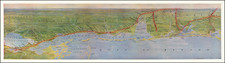
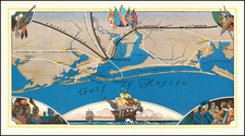
Rare early state of Blunt's sea chart of Florida and the Bahamas, first published in 1833.
Nice coverage of the Bahama Islands. Has a small inset chart of Key West and twelve small recognition views of coastal approaches.
The Coastline of Florida is still sparsely known and highly inaccurate. Even the general shape of the coastline is far wider than its final form. Over the next 15 years, the results of the United States Coast Survey work in the region would radically reshape the coastline and immediate interior features, as the inland waterways, swamps and lowlands became better understood.
Condition Description
Fair to Good restored condition. Engraving on two sheets of paper joined as one blueback chart. Partially restored paper and image loss (part of Key West inset) along left edge. Original hand coloring of lighthouses in red and yellow. Some soiling.

![(Southern Travel Journal) [Manuscript travel journal to Mobile, Alabama by Andrew Clark, Jr. of Methuen, Massachusetts, also Florida coast, and by horseback through Kentucky and Tennessee and up the Mississippi north to Pittsburgh]](https://storage.googleapis.com/raremaps/img/small/93034.jpg)