


|
||

|

|
|

|
Promoting the Southern Pacific To Czech Emigrants -- Hamburg American Line
Striking large format map of the Transmississippi West, promoting the lines of the Southern Pacific Railroad.
The title in Czech notes that it was issued with a publication entitled Czech Settlements in America (České osady v Americe).
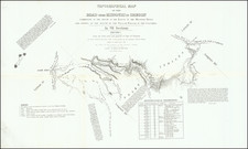
In 1883, Rand, McNally & Co. printed this remarkable map of the Southern Pacific Railway Company and its connections. The company, led by Collis P. Huntington, had recently consolidated several smaller railways in Texas, including the Galveston, Harrisburg & San Antonio Railroad, and the Texas & New Orleans Railroad, with the goal of establishing an additional transcontinental route.
The map details the existing and planned railroad lines. Completed segments of the Southern Pacific and Central Pacific railroads are marked in solid red lines, with white dots indicating the towns along these routes. Red dashed lines show the planned or under-construction routes, while solid black lines represent the railways of competing companies such as the Texas & Pacific and the International & Great Northern, which connected Texas internally and to other major hubs like St. Louis, Missouri.
The "Sunset Route," completed by June 1883, connected New Orleans to California, passing through Texas and linking cities such as Houston, San Antonio, and El Paso. The map also highlights the strategic importance of the port at Galveston and other coastal points like Indianola and Ft. Sabine. The Houston & Texas Central Railway, absorbed by Southern Pacific but retaining its name, is shown extending into northern and western Texas.
The map reveals that while the railway network was extensive in southeastern Texas, areas such as the Panhandle, West Texas, and South Texas, as well as Austin, lacked direct Southern Pacific lines. Planned extensions aimed to bridge these gaps, connecting remote areas to the broader network. The map also indicates the Mexican International Railway's presence in Kinney County, with projected lines reaching deeper into Mexico.
Maritime routes are also featured, with dashed red lines in the Gulf of Mexico and along the California coast denoting steamship lines. These routes connect various coastal cities, including Corpus Christi, Brownsville, and Matamoros in Mexico, and facilitate international travel from New Orleans to Havana, Vera Cruz, and European destinations, as well as from San Francisco to China, Japan, and Australia. These shipping lanes, together with the railroads, contributed to the United States' growing economic influence in the late 19th century.
Rarity
The map is extremely rare.
We note a single example in the collection of the Texas General Land Office.

![[Virginia City, N.T.] Nevada --- The Source of our Silver Wealth --- Panoramic View of Virginia City, Showing The Great Bonanza Mines on the Comstock Lode, Including The Consolidated Virginia, The California, The Ophir, The Gould & Curry, The Hale & Norcross, The Savage, Etc. From Photographs By Watkins of San Francisco, Cal.](https://storage.googleapis.com/raremaps/img/small/72892.jpg)

![Louisiana [Large-Paper Example]](https://storage.googleapis.com/raremaps/img/small/83278.jpg)