|
||

|

|
|

|
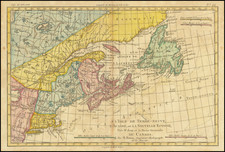
The First Printed Map to Show Five Great Lakes -- Annotated To Show The Claims of Charles de Menou d'Aulnay Following The Acadian Civil War (1640-1645)
Hand annotated example of Jean Boisseau's edition of Samuel De Champlain's 1632 map, first published in Paris in 1643, with annotation informed by the letters patent granted to Charles de Menou d'Aulnay in 1647.
The annotations on this map relate to the activities of the Charles de Menou d'Aulnay de Charnisay, then Governor of Acadia, following his successful battles to consolidate his role as sole Governor against a rival claim and defining the region he governed as stretching from the mouth of the St. Lawrence River to the Virginias.
In early 1647, a royal decree, issued by the King of France in February 1647 and confirmed on April 13, 1647 by Anne of Austria, Regent of France (Louis XIV was still not yet of age), confirmed d'Aulnay as Governor and Lieutenant General in Acadia, New France, and delineated his extensive powers, from legislative authority to exclusive trading rights, establishing a significant chapter in the colonial history of North America. D'Aulnay's appointment and the powers granted to him are a testament to the French crown's strategic interests in North America, particularly in the face of competing British and Dutch claims.
D'Aulnay was granted authority over a vast territory stretching from the Saint Lawrence River along the coasts and islands, as far south as the Virginias. He was empowered to establish laws akin to those in France, negotiate treaties, wage war, and grant privileges and titles based on merit. His authority extended to the establishment of towns and forts, highlighting the strategic importance of Acadia in the broader context of French colonial ambitions.
D'Aulnay was granted exclusive rights to trade fur with the Indigenous populations, a lucrative aspect of the colonial economy. This monopoly on the fur trade, a crucial economic driver, underscored the broader economic motivations behind European colonial expansion in North America. The decree also addressed the exploration and exploitation of mineral resources, further cementing the economic implications of d'Aulnay's governance.
Boisseau's map the first map of the region derived from Samuel de Champlain's seminal 1632 Carte de la Nouvelle France, pre-dating Pierre Du Val's Le Canada . . . by 10 years. While it was long believed that Nicholas Sanson's map of 1650 was the first map to name and illustrate the 5 Great Lakes, in recent years it has been determined that Boisseau's "rare map is, in fact, the first printed to illustrate and name all five Great Lakes, pre-dating the Nicolas Sanson map of 1650. . ."
Derived From the 1632 Champlain Map of New France
Burden notes that Boisseau's map starts with the work of Samuel de Champlain and makes a number of updates and improvements, adding the names that previously appeared only in Champlain's keys. There is no real recognition of the English presence in North America beyond 'Immestan' and 'Chesapeacq Bay'. The nomenclature in New England is entirely that of Champlain.
On Champlain's map of 1632, both Lakes Erie and Michigan were unnamed. Here, Boisseau identifies the lakes as: Lac St. Louis (Lake Ontario); Lac Derie (Lake Erie); Mer Douce ou Lac (Lake Huron), Grand Lac (Lake Superior); and Lac des Puans (Lake Michigan). Champlain's information here was secondhand, and thus he greatly underestimated its size. "Mer Douce ou Lac" is Lake Huron, and "Grand Lac" is Lake Superior, both of which are closer to their actual shapes. Lake Michigan may have been mistaken for the "Lac des Puans" to the northwest, or for the "Grande Riviere qui vient du Midy" that flows to the south. Nevertheless, as early as 1643 there were intimations in Europe that another great body of water still remained unexplored in the heart of North America.
Burden notes that "[a]lthough the configuration and size of [the lakes] are incorrect, this is the first map to delineate and identify all five Great Lakes." Besides Champlain, Boisseau drew from other sources; for example, the naming of Chesapeake Bay is likely derived from John Smith.
Charles de Menou d'Aulnay de Charnisay and the Acadian Civil War
The so-called Acadian War was fought between two French leaders,Charles de Saint-Étienne de la Tour and Charles de Menou d'Aulnay de Charnisay. La Tour had been the first to arrive in New France in 1606 and had become the de facto leader of Acadia in 1623, where he explored the coast of Maine and reported on local Algonquin groups. In 1627, he requested support from Louis XIII regarding the territorial encroachments by the English settlers in Plymouth, who had established at trading post at the mouth of the Kennebec River. After a period of conflict between the British and French, the Peace of Susa and subsequent Treaty of Saint-Germain-en-Laye (1632) confirmed Quebec and Acadia to France. Following the Treaty, Cardinal Richelieu appointed de La Tour lieutenant-general of New France.
Following the establishment of settlements in Acadia, in 1632, Isaac de Razilly became involved, at the request of Cardinal Richelieu, in the colonization of Acadia. Ignoring the prior appointment to La Tour, Richelieu appointed Raizilly to the same title of lieutenant-general for New France.
Razilly landed at La Hève, now La Have, Nova Scotia, with 300 men and 3 monks and built Fort Sainte Marie de Grace. He took possession of Port Royal to establish a French colony and offered the Scottish settlers to buy back their lands and give them a safe trip back to Scotland. Toffund the colony, a company was set up by Razilly and some of his friends which became known as the Razilly-Condonnier company. Together with the Compagnie de la Nouvelle France, an expedition was outfitted to sail to Acadia.
One of of Razilly's lieutenants in Acadia was his cousin, Charles de Menou d'Aulnay de Charnisay, who was instrumental in maintaining the shipping to and from France. D'Aulnay also took on military tasks such as ordering the taking of control of Fort Pentagouet at Majabigwaduce on the Penobscot Bay, which had been given to France in an earlier Treaty, and to inform the English they were to vacate all lands North of Pemaquid. This was accomplished shortly before Razilly's death and resulted in all the French interests in Acadia being restored.
Following the death of Isaac de Razilly for the next four years, La Tour and d’Aulnay co-existed on a strained basis Acadia, "sometimes raiding English posts on the Maine coast to assert French claims and competing for resources, especially the fur trade that came down the rivers, chiefly the Saint John, to the coast. La Tour had a fort at its mouth and another at Cape Sable while d’Aulnay was based at Port-Royal and La Heve."
In 1640, Acadia was plunged into what some historians have described as the Acadian Civil War (1640–1645), when the two legitimate governors clashed. D'Aulnay had the support of the King and Richelieu. La Tour in turn sought aid from the English colonists in Massachusetts, as his Huguenot power base in La Rochelle was ineffective. In 1643, La Tour outfitted an expedition in Boston with men and ships, to counter D'Aulnay's blockade of La Tour's fort and bring new supplies. While the Massachusetts authorities approved an escort of La Tour's ship, they did not approve the ensuing battles, which indirectly lead to Massachusetts Governor John Winthrop briefly losing his position as governor.
The heart of the conflict revolved around strategic locations in Acadia, with La Tour based in present-day Saint John, New Brunswick, and d'Aulnay in Port-Royal (modern-day Annapolis Royal). The war featured several notable engagements:
Battle of Port Royal (1640): La Tour, arriving from Saint John, attacked Port-Royal with two armed ships. Despite initially killing d'Aulnay's captain, La Tour and his men were ultimately forced to surrender. This defeat led d'Aulnay to retaliate by establishing a blockade of La Tour's fort at Saint John.
Blockade of St. John (1642): For five months, d'Aulnay blockaded the river to defeat La Tour at his fort. In a bold response, La Tour arrived from Boston with four ships and 270 men in July 1643, successfully taking back Fort Sainte-Marie.
Battle of Penobscot (1643): Following the blockade, La Tour pursued d'Aulnay to Penobscot Bay. D'Aulnay ran two of his ships aground to form a blockade, resulting in a skirmish at a nearby mill with casualties on both sides.
Second Battle of Port-Royal (1643): La Tour again tried to capture Port-Royal, breaking d'Aulnay's blockade with a fleet of five ships. However, despite inflicting casualties and seizing supplies, La Tour did not attack the fort itself, which was defended by twenty soldiers.
Siege of St. John (1645): In a dramatic turn, while La Tour was in Boston, d'Aulnay attacked La Tour's fort at Saint John on Easter Sunday with 200 men. The fort's defenders, led by La Tour's wife Françoise-Marie Jacquelin, held out for five days. Following her surrender under the promise of quarter, d'Aulnay treacherously executed the garrison and Françoise-Marie Jacquelin died weeks later.
In February 1647, d'Aulnay received substantial recognition and support from the French court, largely due to the patronage of Pierre Séguier, the Chancellor of France. He was granted letters patent that not only lauded his services but also confirmed his authority as the governor of Acadia, which was expansively defined as stretching from the St. Lawrence River to Virginia. This grant also gave him exclusive rights to the lucrative fur trade, a privilege that heightened tensions with competing interests.
D'Aulnay's assertive enforcement of these rights, as early as 1644 and 1645, involved patrolling coasts to seize fishing vessels engaged in the fur trade and capturing ships from various regions including the Basque country, Bordeaux, and Brittany. His aggressive stance extended to taking control of Fort Saint-Pierre at Cape Breton and the fort at Nipisiguit (Bathurst, N.B.), actions that were difficult to justify and led to numerous legal disputes and appeals to the Conseil du Roi. Despite the protests of the Compagnie de la Nouvelle-France and others affected by his policies, d'Aulnay maintained a strong position at court until his death in 1650.
Financially, d'Aulnay's administration was strained. By 1648, the colony's deficits had accumulated to over 200,000 livres. His financial backer, Emmanuel Le Borgne de Belle-Isle (who would go on to become the Governor of Acadia), frustrated with the lack of returns, demanded payment, and eventually seized d'Aulnay's estate. Despite these challenges, d'Aulnay continued to seek other sources of support and was engaged in land clearing when he met an untimely death in 1650, after his canoe capsized in the Port-Royal basin.
D'Aulnay's death left behind a heavily indebted estate and eight young children. His widow, Jeanne Motin, in a twist of fate, married his former adversary, La Tour.
Hand Written Annotations & The Acadian War
The hand-written notes on the map largely related to the efforts of Charles de Menou d'Aulnay de Charnisay (d'Aulnay) to secure the French claims, the competing claims of the Dutch and English as far south as Florida and the details of the French forts in Acadia.
C’est le Gouvernement de Monsieur d’Aunay Charnisay depuis l’embouchure de la grande rivière St Laurent tant du long de la coste de la mer et iles adjacentes que dedans de la terre ferme jusque aux Virginies
Translation: This is the Government of Monsieur d'Aunay Charnisay from the mouth of the great St. Lawrence River, along the coast of the sea and adjacent islands as well as inland up to the Virginias.
A. Fort de Pentagouet de 4 bastions et vin[g]t pièces de canon
Translation: Fort Pemetegoit with 4 bastions and twenty pieces of cannon
B. fort de la riviere St Jan de quatre bastions et vin[g]t pièces de canon
Translation: fort of the St Jan river with four bastions and twenty pieces of cannon
C. Le port Royal fortifié de 4 bastions et vin[g]t pièces de canon de [?]
Translation: Port Royal fortified with 4 bastions and twenty [g]t cannon pieces of [?]
D. La Heve premier lieu ou le seigneur d’Aunay prit terre
Translation: La Heue first place where the Lord of Au[l]nay landed
(Bottom Left Corner): Les virginies sont icy
Transalation The Virginias are here
The annotations show the extent of D'Aulnay's letters patent claims as far south as Virginia, which lasted more of less from 1645 to his death in 1650. Given the contemporary hand and content, it would seem that the text narrates the claims which Aulnay following his defeat of La Tour (and likely after the French Government validated his claims and the scope of Acadian lands (From the St. Lawrence to the Virginias).
The text of the first note corresponds nearly exactly to the letters patent granted to D'Aulnay in 1647. The additional lines drawn along the east coast, identifying to lands belonging to the English and Dutch, reflect the imperfect understanding of the boundaries of the various colonial powers at the time, more or less consistent with that depicted on De Laet's seminal map of the region.
It is also possible that the map was drawn shortly after the Dutch re-took the colonial claims of Sweden on the Delaware River in 1654-55, which would suggest that the map's annotations were a retrospective look at D'Aulnay's claims, perhaps as a part of Emmanuel Le Borgne de Belle-Isle's attempts to enforce his rights as the heir and sponsor of D'Aulnay, which would lead to Le Borgne's becoming governor of Acadia in 1657.
States of the Map and Rarity
The present example is the rare first state of Boisseau's map.
The map is known in 2 states:
- State 1: 1643 date.
- State 2: circa 1664 without the imprint and date in the cartouche, and with the addition of London, Bristou, Gotenbourg, N. Amsterdam and Christina, along with degrees of longitude and latitude.
Both states of the map are rare on the market.
Burden, The Mapping of North America I 261;
McCorkle, New England in Early Printed Maps 643.1;
Verner and Stuart-Stubbs, The North Part of America 5;
Kershaw, Early Printed Maps of Canada I:83.


![Carta rappresentante una parte della Baja Hudson, e le Regioni a Maestro dell'America Settentrle. [Map representing a part of Hudson Bay, and the regions to the northwest of North America.]](https://storage.googleapis.com/raremaps/img/small/95989.jpg)