|
||

|

|
|

|
This map of Calcutta and Howrah, published in 1933, represents a comprehensive urban and geographical survey of the cities at the beginning of the 20th century. Created under the auspices of Colonel H. J. Couchman, D.S.O., M.C., Officiating Surveyor General of India, it includes railways, tram lines, significant buildings, religious edifices, post offices, police stations, district and municipal boundaries, metaled roads, wooded areas, and spaces designated for gardens, lawns, grass, and cultivation. Engraved and heliozincographed at the Survey of India Offices in Calcutta, this map is a testament to the domestic cartographic and surveying skills of the era.
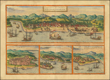
At this time, Calcutta was the capital of British India and a pivotal commercial and cultural hub, reflecting the complexities of colonial rule and urban development. The detailed representation of various religious structures such as temples, mosques, and churches, alongside administrative buildings and public utilities, provides insights into the multicultural fabric and colonial governance structures of the cities.
The inclusion of a bound alphabetical index and the use of a tape indicator highlight the map's utility for both residents and visitors in navigating the bustling streets and emerging suburban areas of Calcutta and Howrah.