|
||

|

|
|

|
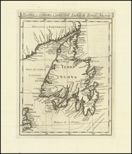
A handsome example of the 1766 edition of Captain James Cook's sea chart of the Great Northern Peninsula of Newfoundland and contiguous coastline of Labrador, based upon surveys undertaken by Cook as the official British Surveyor of Newfoundland (1764-1767).
The present work is among James Cook's earliest published sea charts. Following the end of the French & Indian War in 1763, Cook was stationed in Newfoundland, where he undertook the first modern surveys of Newfoundland, producing several extremely rare sea charts in 1766 including the present chart and his Chart of Part of the South Coast of Newfoundland . . . .
The present chart is one of the two earliest printed charts to bear Cook's name, providing a detailed charting of the strategically important entrance to the Gulf of St. Lawrence via the Straits of Belle Isle.
From Seaman to Circumnavigator
James Cook's royal naval career began on June 17, 1755, when he enlisted as an able seaman at Wapping in East London. A month after joining his first ship, the 60-gun Eagle commanded by Captain Joseph Hamar, Cook was promoted to master’s mate. The Eagle would next be captained by Hugh Palliser, who recognized Cook's skills and aided in his training and early advancement. Within two years, Cook had earned the rank of master, a rank he held for the next ten years, including all his years in Newfoundland.
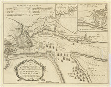
After serving on the frigate Solebay, Cook was sent to North America in 1757 amid the Seven Years' War, serving as master aboard HMS Pembroke, under Captain John Simcoe. During the siege of Louisbourg, with the encouragement of Simcoe, Cook acquired surveying and chart-making skills under the tutelage of Samuel Holland, a Dutch-born engineer serving with the British army, who had been assigned to prepare maps of Louisbourg during and after the British siege. Cook's earliest cartographic work was his participation in the creation of a detailed charting of the Saint Lawrence River, which would later catch the attention of his commanding officers. Admiral Sir Charles Saunders, impressed by Cook’s work, facilitated the publication of these charts in England, although without credit to Cook in the printed title.
After the capture of Louisbourg, the British forces spent the winter in Halifax. In May 1759, they embarked upon a strategic journey up the Saint Lawrence River, aiming for the French stronghold of Quebec City. Cook played an instrumental role in this mission. His ship aidied the transport of troops and charted the river to inform the upcoming siege. Quebec capitulated to the British in September 1759. Following the taking of Quebec, Cook transferred to the 70-gun Northumberland. Alexander, Lord Colvill, who had been Northumberland’s captain, was promoted to commodore with William Adams as his flag captain and Cook as master. Cook remained for the most part in Halifax for the next 2 years, until a French naval attack on St Johns resulted in the Northumberland participating in a blockade of the French in St. John’s, which marked the beginning of Cook's time in Newfoundland.
Once settled, Cook was sent to Conception Bay in the company of J.F.W. Des Barres who, like Samuel Holland, was a military engineer and surveyor. Des Barres had been ordered by Colonel Amherst to assess the damage to the defenses on Carbonear Island and to draw up designs for new defense works. Colvill tasked Cook with mapping the waters adjacent to Harbour Grace and Carbonear. Cook also used his time to draft charts of Bay Bulls, where the French had first landed, and St. John’s. When the Northumberland returned to Placentia in October, Cook also charted that harbor. By the time Northumberland returned to England with Palliser’s ships, Cook had amply demonstrated his skills at chart-making to his superiors.
While his military service was at an end, Cook had earned a remarkable reputation. In a letter to the Admiralty secretary, Lord Colvill praised Cook’s skills as a chart-maker, remarking on his “Genius and Capacity” and declaring that his work “may be the means of directing many in the right way, but cannot mislead any.” Thomas Graves, who would continue to serve in the dual role of governor and commander-in-chief of the Newfoundland station in 1763, had also been very impressed by Cook’s abilities as a chartmaker, and urged the Admiralty to employ Cook to survey the coasts of Newfoundland. In 1763, with the Peace of Paris expanding British territory to include coastal Labrador, Graves urged the Admiralty to commission a detailed survey of the new territories and recommended Cook for the task. Consequently, Cook was appointed as the Surveyor of Newfoundland in the Spring of 1764.
Cook's Newfoundland survey work was not simply in aid of navigation. Having just been taken from the French, there were significant sovereignty issues to address. Cook's extensive mapping of Newfoundland and Labrador aimed to furnish the British Empire with detailed knowledge of coastlines recently obtained from or disputed with the French. This geographic intelligence was critical for the Britain to effectively govern these new acquisitions and to deter any French endeavors to overstep the boundaries set by treaties. The surveys amassed vast details on economic prospects and provided intricate navigational instructions. However, their primary objective was to assert British sovereignty. Among all the cartographic works created for this goal, Cook's charts were unparalleled in precision and clarity.
Cook's initial project was charting the island of St. Pierre, which had to be completed promptly as St. Pierre and Miquelon were returned to France after the Peace of Paris. Cook produced an exemplary chart just as French ships arrived to claim the territory. Following this, Cook charted Northern Peninsula harbors and various harbors along the newly British Labrador coast.
Cook's surveys from 1763 to 1767 were strategic, focusing on areas of British sovereignty concerns—territories newly British, soon-to-be French, or contested by the French. His work on the Northern Peninsula in 1764, the South Coast from Burin Peninsula to Bay d’Espoir in 1765-66, and the largely uncharted West Coast of Newfoundland in 1767 was pivotal in asserting British claims against French territorial ambitions.
Cook’s survey techniques were innovative, combining land-based trigonometry with maritime soundings, culminating in remarkably accurate charts that were invaluable for navigation and fisheries. His charts were so detailed that they were later published for commercial use. His detailed charts became an essential part of Jefferys "The North-American Pilot," serving as a primary navigational tool for these regions for over 100 years.
The exceptional quality of Cook's charts was instrumental in his reassignment from Newfoundland to lead the first of his three historic Pacific voyages. In 1767, Cook was appointed by the Admiratly to lead the first of the three Pacific Voyages that would make him the foremost explorer of the 18th Century.. His extensive experience, both in cartography and command, made him the Admiralty's foremost choice for this ambitious undertaking. Cook's meticulous surveys of Newfoundland and Labrador were not only a testament to his skill but also foundational to his later Pacific explorations as Captain of the HMS Endeavour on three pivotal voyages across the Pacific.
States of the Map & Rarity
The chart is known in two states, both dated 1766.
- State 1: Dated 1766. With note below title "Published by Permission of the Right Honourable Lords Commissioners of the Admiralty by Iames Cook and Sold with a Book of Directions by I. Mount & T. Page on Tower Hill, London.
- State 2: Dated 1766. With note below title "Published by Permission of the Right Honourable Lords Commissioners of the Admiralty by Iames Cook and Sold with a Book of Directions by I. Mount & T. Page on Tower Hill, London. Price 4 Shills.
Both states are extremely rare.
OCLC locates examples in the British Library (unknown state), Bibliotheque National de Paris (states 1 and 2) and the Library of Congress (unknown state). We also note examples at the National Library of New Zealand and Yale (state 1).
We note a single example at auction (Sothebys 1967) and no dealer catalog records.
![[French America and the Triangular Trade] L'Amérique Françoise Où son Décrites La France Nouvelle, La France Insulaire, La France Equinoctiale, et autre pais Par P. Du Val d'Abbeville Geographe du Roy . . .](https://storage.googleapis.com/raremaps/img/small/91968.jpg)