|
||

|

|
|

|
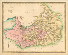
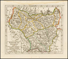
Fine Map of Poland & Lithuania As They Existed In the First Part of the 19th Century
The map a tale of power struggles, shifting boundaries, and evolving identities. To understand the map, one must delve into the historical context of the region during the first half of the 19th century. The landscape, riddled with dynamic geopolitical changes, was defined by the ambitions of powerful empires, the aspirations of the Polish and Lithuanian people, and the geographical significance of the region.
By the end of the 18th century, Poland had suffered three partitions at the hands of the Russian Empire, the Kingdom of Prussia, and the Habsburg Monarchy of Austria. These partitions, executed in 1772, 1793, and 1795, effectively wiped Poland off the map. The Poland portrayed on the map was but a shadow of its former self, divided into various zones of influence - Russian, Austrian, and Prussian Poland.
Following the Napoleonic Wars and his brief reincarnation of the Polish state as the Duchy of Warsaw, the Congress of Vienna in 1815 led to the creation of "Congress Poland" or the "Kingdom of Poland", a quasi-independent state under Russian suzerainty, covering only a fraction of the historical Polish lands.
Historically united with Poland through the Polish-Lithuanian Commonwealth, Lithuania too underwent a transformation in its geopolitical stature. By the map's timeframe, the majority of Lithuanian lands were firmly under Russian control, with regions like Wilno (modern-day Vilnius), Grodno, and Minsk becoming integral parts of the Russian Empire.
Throughout the first half of the 19th century, Poland and Lithuania witnessed a series of uprisings against foreign dominance. Notably, the November Uprising of 1830-31, which was a major armed rebellion against Russian rule in Poland and Lithuania. While it was ultimately quelled by Russian forces, it instilled a sense of national identity and aspiration for freedom among the Poles and Lithuanians.
The southern fringes of the map depict Galicia, a region that became part of the Austrian partition and, further south, Moldova, a historic region divided between the Ottoman and Russian Empires. These regions were significant for their own complex histories and affiliations, bridging the worlds of Central and Eastern Europe.
The map also includes a wide swath of Western Ukraine.
A striking feature of the map is its meticulous depiction of the roads of the region, which would have been pivotal for trade, military movements, and other forms of communication during that period. Additionally, the map details several dozen Palatinates and towns, reflecting the administrative and urban landscape of Poland and Lithuania. In the context of the map, a Palatinate, known locally as a "Palatinatus" or "województwo", refers to an administrative region or division. These Palatinates were historically governed by a Palatine, an official with varying responsibilities ranging from judicial to military, depending on the period.
In conclusion, the 1830 "Poland & Lithuania" map encapsulates a pivotal moment in the histories of these two intertwined nations. It's a testament to the resilience of their people amidst the geopolitical machinations of larger powers. This period marked not just the struggles and subservience of Poland and Lithuania but also sowed the seeds of a resolute desire for national self-determination, which would play out profoundly in the ensuing decades.
The Lizars were a Scottish family of engravers and printers who produced many views and maps. Daniel Lizars Sr. (1754-1812) was the son of a shoemaker, but he apprenticed with Andrew Bell, a printer and engraver. Lizars set up his own printworks near St. Giles Cathedral and took on his own apprentices, including George Bartholomew, whose son John would go on to found the important mapmaking firm later know as John Bartholomew & Son Ltd.
Daniel Sr. had three sons: Daniel Jr., John, and William Home. He also had a daughter, Jane Home. Daniel Jr. (1793-1875), the youngest of the boys, apprenticed in his father’s shop alongside George Bartholomew. When his father died in 1812, Daniel Jr. took over much of the business, expanding it and specializing in maps. The company went bankrupt in 1832, however, and Daniel emigrated to Canada.
John Lizars (1792-1860), the middle son, studied medicine and became Professor of Surgery at the Royal College of Surgeons of Edinburgh, as well as senior surgeon at the Royal Infirmary of Edinburgh.
William Home Lizars (1788-1859), the eldest, also apprenticed in his father’s shop. After learning engraving, William entered the Trustees’ Academy to learn under John Graham. He was a skilled painter and artist. When his father died, and after his Daniel Jr. left, he carried on printing and invented a method of etching that looks like wood engraving.
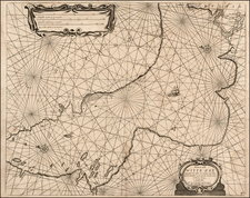
![[Riga & Environs]. Der Rigische Kreis / Le Cercle de Riga](https://storage.googleapis.com/raremaps/img/small/69148.jpg)