|
||

|

|
|

|
Extensively Annotated in an Early Hand
18th Century Map of Kentucky and Environs Printed in America
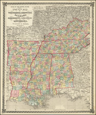
Important early map of Kentucky, showing primarily the region around the Ohio and Tennessee Rivers, from northern Georgia to Western Territory.
The present example of this early map of Kentucky is a remarkable artifact, extensively annotated by an early owner (see complete explanation below).
Includes all of Kentucky, most of Tennessee called South Western Territory, and Tennessee Government. In the upper left, the North Western Territory appears, with tracts of land called New Jersey Company, Wabash Company, and Genl. Clarks Grant 150,000 Acres.
The map extends west to New Madrid, south to Creeks Crossing Place and a fort near Muscle Shoals, east to Harmans Station in Kentucky. Settlements include Louisville, Danville, Lexington, Boonesborough, Franklinville, Washington, Lees Town, Woodford, Lincoln, Baird's Town, Lystra, Madison, St. Asaph, Crab Orchard, Patteson's Mill, Bryan's Lick, Howard's Settlement, Herod's Town, Bourbon, and Riddle's Station.
Shows Southwestern Territory, Tennessee Government, area reserved for the North Carolina Troops, Donation Lands from the Commonwealth of Virgnia, etc. A number of counties are located, as are towns, roads, rivers, courthouses, etc.
Annotations
The map is extensively annotated with contemporary notes regarding Kentucky and the neighboring regions, as well as a road that seems to lead from Glover's Trace (west of Nashville) to the Ohio River.
Notes include:
The Ohio River is beautiful greatly abounding in fish and is navigable almost to its source. His: Louisiana 301
Chickasaws under the protection and sovereignty of the United States by the Treaty of Hopewell in 1786
This point [New Madrid] is 300 leagues from the Sea. His: Louisiana 299
This of all the colony is that in which with the greatest ease, they grew Wheat, Ray & Other like grain for the sowing of which you need only turn earth in the slightest manner. His: Louisiana 301.
Additional Notes note identifies Indiana Territory and two observations from Bartram regarding rivers flowing from South Carolina into Tennessee.
One of the earliest obtainable maps of Kentucky and vicinity and one of the most interesting regional maps of the period.
Following Mathew Carey’s publication of the American Atlas in 1795, the second large format atlas published in America was produced by John Reid of New York in 1796. The project began as an atlas to accompany William Winterbotham’s An Historical, Geographical, Commercial and Philosophical View of the United States, but was also sold separately under the title The American Atlas.
Reid’s atlas included 20 maps. In addition, John Russell’s plan of Washington, D.C. is also bound into some copies of the Atlas. Reid’s atlas was a collaborative work, with 9 of the maps engraved by Benjamin Tanner, 5 by David Martin, two by D. Anderson and one each by John Scoles and John Roberts. Two of the maps do not include engraving credits. Each of the engravers was probably working in New York (including Tanner, who had not yet relocated to Philadelphia). According to the various entries for the maps in Wheat & Brun, the cartographic content of the maps is drawn largely from Carey’s first atlas of 1795.
![The United States of America Confirmed By Treaty 1783 [shows Franklinia]](https://storage.googleapis.com/raremaps/img/small/84491.jpg)