|
||

|

|
|

|
Stock# 100991
Description
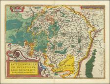
An attractive example of this early map of Luxembourg, which appeared in Petrus Kaerius's (Peter Van der Keere) Germaniae Inferior id est, XVII Provinciarum ejus novae et exactae Tabulae Geographicae, first published in Amsterdam in 1617.
The map includes a view of the City of Luxembourg, its coat of arms, and indigenous costumes.
Van der Keere's atlas was the first separately published atlas of the Low Countries.
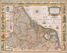
The map includes a view of the town of Middelburg, a compass rose and costumes showing typical regional dress.
Condition Description
Engraving with original hand-color on 17th-century laid paper. Trimmed to the neatline and mounted to modern laid paper for structural support. Nickel-sized loss at center near “Leodiensis” integrated with the surrounding image area by use of hand-drawn ink and watercolor. Good to VG.