|
||

|

|
|

|
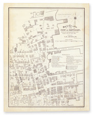
This cadastral mapmeticulously records the historical landscape of Fort Hill Farm, associated with Lieutenant John Fanning and Captain Samuel Fish, in Groton, Connecticut. It serves as a documentary piece, marking the evolution of land ownership from the acquisition by John Pynchon in 1695, and traces the subsequent changes up until 1904.
Embedded within the lines and notations of the Map of the Fort Hill Farm lies a detailed account of land distribution and ownership, illustrating the specific details of property extent and the built environment as they stood at the dawn of the 20th century. This map is not merely a geographical representation; it is a historical document that provides a window into the agrarian history of Connecticut.
As a record of land transactions and ownership, the map stands as an informative piece for those interested in the patterns of land use and administration in New England. It is particularly valuable for historical research, offering data on the size and boundaries of parcels, the identification of landowners, and the existence of buildings over a period spanning more than two centuries.
The map was prepared for the History of the Fanning family by Walter F. Brooks, thus also contributing to the study of family histories within the region.
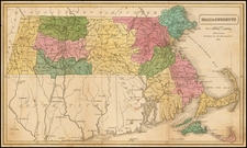
![[Special Promotional / Sample Map for Rand McNally Business Atlas] Massachusetts](https://storage.googleapis.com/raremaps/img/small/89042.jpg)