|
||

|

|
|

|
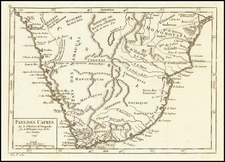
John Seller's exceedingly rare and attractive chart of the Cape of Good Hope and present-day Cape Town. The chart was published in both Seller's Atlas Maritimus and Book III of the English Pilot. The chart is distinguished by the splendid perspective view of the Cape and Table Mountain dominating the upper section of the sheet, and incorporating a small inset view of the Dutch fort. The title appears upper left supported by two skin-clad native Hottentots bearing spears and surrounded by sheep. Below a finely detailed chart of the coasts of the Cape from Saldanha Bay to False Bay. This equally rare edition by Mount and Page is updated with a new titlepiece and includes the names of Table and False Bays. Full orginal color. Slightly toned with a bit of mat burn outside the rinted image, but otherwise a nearly flawless example of this extreme rarity. The various editions include very subtle changes, most notably to the cartouche and table which appears in some editions.
![[With Photos of an Early Owner!] Troye's Map of the Transvaal or S.A. Republic](https://storage.googleapis.com/raremaps/img/small/87453.jpg)