


|
||

|

|
|

|
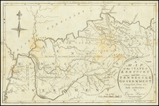
First State with Extensive Annotations By An Early Owner
Remarkable annotated example of the first state of John Reid's map of Georgia, shown extending to the Mississippi, along with East and West Florida.
The present example has been augmented with outline and wash color to illustrate boundaries and regions, with lengthy historical notes on both the the back relating to Georgia's history. The Mississippi Territory is shown in its pre-1804 configuration (1798 to 1804).
In the east, Georgia includes some coastal counties, towns, rivers, islands, lakes, etc. Tallassee County is identified as claimed by the State of Georgia previous to the Treaty of New York. The Akenfonogo Swamp is shown. The boundary line settled by I Stewart, Supt. British Gov't is also shown, claiming for Florida regions which are here shown in Georgia. A number of Indian settlements are shown on the Lower Chattahochee River, and then again in the northern Cherokee Lands.
The Countries of the Cherokees and Creek are shown, along with the Seminole, Appalachy, Muskogee, Chactaw and Chicasaws lands. The rivers which converge to form Mobile Bay show a number of early settlements, especially along the Alabama River. Most of the region covered is Indian lands, with named settlements and other details.
An interesting early map of Georgia, still including all of Mississippi and Alabama. This map appeared in Reid's American Atlas, the second earliest folio atlas of America published in the United States.
Manuscript
The present example is substantially enriched by the inclusion of lengthy passages, toponyms, and border amendments added by an early owner. The owner was an astute compiler who referenced numerous printed sources in formulating his notes. This is evidenced by some of the passages we excerpt here:
-The mouth of the Yazoo was found by Mr. Gauld to be 32° 37 and by Mr Purcel 32° 27". } By the British Government in 1760 was found to be in 32° 39'
-Yazoo Indians are extinct
-The southern boundary of the United States from a letter from Colonel Hawkins to his Excellency Govr Jackson dated Creek Nation 17th July 1799 in the Commercial Advertiser of Aug. 14th. 1799 / ???? the River about 20 miles above the mouth of the ???? River.
A remarkable survival.
Following Mathew Carey’s publication of the American Atlas in 1795, the second large format atlas published in America was produced by John Reid of New York in 1796. The project began as an atlas to accompany William Winterbotham’s An Historical, Geographical, Commercial and Philosophical View of the United States, but was also sold separately under the title The American Atlas.
Reid’s atlas included 20 maps. In addition, John Russell’s plan of Washington, D.C. is also bound into some copies of the Atlas. Reid’s atlas was a collaborative work, with 9 of the maps engraved by Benjamin Tanner, 5 by David Martin, two by D. Anderson and one each by John Scoles and John Roberts. Two of the maps do not include engraving credits. Each of the engravers was probably working in New York (including Tanner, who had not yet relocated to Philadelphia). According to the various entries for the maps in Wheat & Brun, the cartographic content of the maps is drawn largely from Carey’s first atlas of 1795.
![[Supplying The Confederacy -- Letter Regarding Supplies for the Confederate Army ]](https://storage.googleapis.com/raremaps/img/small/95452.jpg)

![[Port Lucie/Indian River to Cape Hatteras] East Coast of North America from the U.S. Coast Survey and the most recent authorities. Sheet V. . . . 1870](https://storage.googleapis.com/raremaps/img/small/90697.jpg)