|
||

|

|
|

|
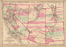
Detailed Map of Colorado Territory in 1866, with original text.
Scarce map of Colorado Territory, showing sixteen counties and a large Indian Reserve. The reserve is divided into Cheyenne and Arapahoe tribes. The map also indicates locations of gold and silver mines. Extensive watershed information and mountains are shown in hachure. Shows all mining communities, forts, railroads, and more.
The map is here present, as issued, in Hollister's The Mines of Colorado, published in 1867 in Springfield, Massachusetts, expanded from the edition published the same year at Central City, Colorado, under the slightly different title: The Silver Mines of Colorado (Central City, 1867). Hollister's book is an extensive guide to Colorado mines, and provides a view of the geography, geology, climate, agriculture and the like. Extensive information on over 165 mining enterprises.
Ovando J. Hollister (1834-92) left Massachusetts for the West, first to Kansas, then to Colorado. A Civil War veteran who served in the First Colorado Cavalry, Hollister was editor of the Daily Mining Journal out of Black Hawk, Colorado. His book was clearly issued in anticipation of the transcontinental railroad.
The book is often missing the important map, published by the Major & Knapp Engraving, Manufacturing & Lithographic Company in New York.