|
||

|

|
|

|
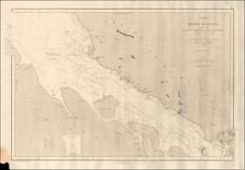
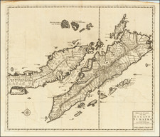
Raffles' Map of Singapore, 1830
Published in 1830, this map is an important early depiction of Singapore, appearing in Lady Sophia Raffles' "Memoir of the life and public services of Sir Thomas Stamford Raffles." Created four years after Sir Thomas Stamford Raffles' death, it shows Singapore shortly after the Raffles Town Plan began shaping the city.
The map focuses on the developing colonial city, highlighting key features such as the flagstaff on Government Hill, later part of Fort Canning, used for ship signals. It shows local rivers, Malay settlements along the coast, and names of hills ('bukit'), capes ('tanjung', here as 'tanjong'), and other coastal areas. It also marks 'Point Franklin or Tanjong Changi,' the location of Singapore's main airport today.
The map is rooted in the history of Singapore's founding as a British colony in 1819 by Sir Thomas Stamford Raffles. Raffles played a key role in acquiring Singapore from the Sultanate of Johor and set it up as a free port. The map thus captures a moment when Singapore was transitioning under British rule.
Raffles' vision for Singapore included structured development and racial and social segregation, allocating different areas to European, Chinese, Indian, Bugis, Arab, and Malay communities. This plan influenced the city's development, though not all aspects were implemented as intended.