|
||

|

|
|

|
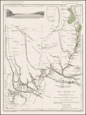
Tracking the Movements of the Third Shanghai Expeditionary Force During the Battle of Shanghai - October 25 to October 30, 1937
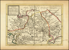
Rare variant edition of Faber's 1936 map of Shanghai and vicinity, which has been annotated in pencil to show the latter stages of the Battle of Shanghai, to illustrate the advances of the Third Shanghai Expeditionary Force (T.S.F.) during the later part of October 1937.
As discussed below, the map would seem to show movements of the Japanese troops between October 25 and October 30, 1937, as the two forces fought the final stages of the Battle of Shanghai. The map itself is heavily annotated in blue pencil, apparently providing the location of a number of roads not printed on Faber's map. In addition, pencil routes are shown moving south from Liuho, along with the initials T.S.F. in several places, along with penciled in dates and placed names.
The map almost certainly illustrates the movements of the Japanese forces (T.S.F.), beginning in the north from Liuho to Dachang (Tachang on the map). The initials T.S.F. appears Notes appear on the map suggesting skirmishes on October 25 (25/10) and October 26(26/10), with the names Wenchao Creek, Miahong and Koochiachai. To the southwest, a second and third Japanese offensive line are shown, with the dates of October 27 (27/10), October 28 (28/10) , October 29 (28/10) and October 30 (30/10), as the Japanese push further south toward the center of Shanghai, with the name Paoshan and Chabei (Zhabei) shown.
Below these notes, an area is marked "City" with the word Nantao written and notes suggesting river crossings and perhaps another assault from the Whangpoo River, with another area demarcated to the west. This is likely the area where the Chinese 88th Division remained in Zhabei to defend the Sihang Warehouse.
Map Overview
Faber's map was originally published for use by European and Americans living in Shanghai, to assist with the local road system. We note a different edition, published for the Automobile Club of China, entitled Official Road Map of Shanghai and District.
The focal point of the present map is transit, with roads shown in blue and red. As noted in the legend, "settlement or concession licenses are not valid on roads shown in red." This phrase addresses the legal and administrative distinctions that existed in Shanghai during that time, particularly in relation to the International Settlement and the French Concession. Shanghai in the 1930s was a city divided into several zones with different administrative controls. The International Settlement was an area controlled jointly by the British and Americans, along with other international powers. It had its own police force and legal system. The French Concession was an area managed by the French, which had its own administration separate from the International Settlement and the rest of Shanghai. The rest of Shanghai was under Chinese jurisdiction. Each of these areas issued their own licenses for various purposes, including driving. A license issued in the International Settlement or the French Concession would not necessarily be valid in areas controlled by the Chinese government. On the map, roads shown in red likely represented areas under Chinese jurisdiction or special administrative zones where the legal authority of the International Settlement and French Concession did not apply. Therefore, licenses from these concessions would not be valid on these roads.
Battle of Shanghai
The Battle of Shanghai, fought between August 13 and November 26, 1937, was a major early battle in the Second Sino-Japanese War. The conflict involved the National Revolutionary Army (NRA) of the Republic of China and the Imperial Japanese Army (IJA) of the Empire of Japan. Noted for its sheer scale and intensity, the battle is considered by some historians as the first major engagement of World War II. Despite being outgunned and outnumbered, the Chinese forces resisted fiercely, surprising the Japanese, who expected a swift victory.
In August 1937, the battle began with the NRA trying to remove Japanese troops from downtown Shanghai. This initial phase saw intense urban combat, but Chinese forces were hampered by their inferior arms and the strength of Japanese fortifications. The second phase, from late August to October, was marked by Japanese amphibious landings and brutal house-to-house fighting. The Japanese gradually gained ground, pushing the Chinese forces back despite their determined resistance. This phase was characterized by extremely high casualties on both sides.
The final phase of the battle, starting late October, involved Chinese retreats under the pressure of Japanese flanking maneuvers. By late November, the Chinese army, significantly weakened and exhausted, was forced to withdraw from Shanghai.
During the month of October, the following summarizes the activity.
-
October 1: The Japanese decided to launch an October offensive. Japanese troop strength increased in Shanghai, with invasions in towns like Liuhang.
-
Early October: Battles were fought along the Yunzaobang River, with the Chinese and Japanese armies experiencing seesaw battles without much change in the frontline.
-
October 17: The Guangxi Army joined the battle in Shanghai.
-
October 20: The frontline had only moved five kilometers since September 11.
-
October 25: Dachang fell to the Japanese, leading to the Chinese withdrawal from downtown Shanghai.
-
October 26: Chinese troops began retreating from Shanghai's urban center. A battalion of the 88th Division remained in Zhabei to defend the Sihang Warehouse.
-
End of October: The Japanese planned landings in Jinshanwei, south of Shanghai, to encircle the Chinese army from the north and south.
Rarity
The Faber / Automobile Club Map of China is quite rare. With the annotations, the map is a unique survival.
![[ Beijing ] Peking](https://storage.googleapis.com/raremaps/img/small/101285.jpg)