|
||

|

|
|

|
Stock# 100359
Description
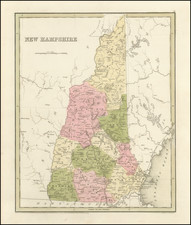
Rare and attractive 1791 map of New Hampshire engraved in Boston by Samuel Hill.
The map shows towns, county boundaries, and "Line of Masons Patent, 1787."
According to Cobb, the acreage of the Dartmouth Grant has been changed from the original manuscript.
States
The map was reprinted in 1812 or '13 with the note '42,000 Acres | to Dartmouth College.' altered to read '40,960 Acres | to Dartmouth College.'
Condition Description
Engraving on 18th-century laid paper. Minor loss to top centerfold, professionally reinstated.
Reference
Cobb, New Hampshire Maps to 1900, An Annotated Checklist, 65.